Names on the Land
A Dictionary of Kalamazoo County Place Names
A | B | C | D | E | F | G | H | I | J | K | L | M | N | O | P | R | S | T | V | W | Y
 Colorful names alone often indicate the history and early settlement of a place. The following list is partly for reference and partly for browsing. We expect to add other names as we find information about them, so check back later if you do not find what you are looking for. A short list of sources appears at the end of most entries. A more detailed description of sources appears at the end of the web page.
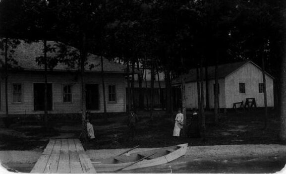
Adams Park
 Adams Park, 1936
Section 4, Brady Township, A resort on the southeast side of Indian Lake, originally platted in 1911, but not developed until the 1920s. It was reachable only by boat, and consisted of some cottages, a hotel, a public beach and possibly a store. After a fire partially destroyed the hotel about 1925, the property was sold to the Church of the Nazarene. The residential area along that stretch of the lake is still known as Adams Park. (1918 topo map, Leonidas Quadrangle; Chad Maps; and Vicksburg Village views on rootsweb.)
Alamo
 Alamo General Store, 1990. KVM photo
A small settlement centered at D Avenue and 6th Street. Named for its township. First settled by John G. Tarbell in 1841. (Durant, p.297)
Alamo Township
The northwestern-most township in Kalamazoo County, organized in 1838 and named for Col. David Crockett and his comrades, who died defending the Alamo in the revolt of Texas from Mexico in 1836. (Snow; Durant; Romig)
Aldrich’s Prairie
A small prairie, possibly in extreme northern Cooper Township. Early sources attribute it to Kalamazoo County, but later research indicates that it was probably mostly in Allegan County. Named for Isaac Aldrich who “maintained a tavern at the ford of the river where his farm was located ‘a mile below the present site of Plainwell.’” The 1840 census and several references in the 1880 Allegan County history make it clear that Aldrich lived in Gun Plain Township, Allegan County. Aldrich’s Prairie does not appear on the WMU Presettlement Vegetation of Southwestern Michigan, a map constructed from the original surveyor’s notes. The omission implies that the prairie was very small, probably less than a half mile wide. (Mich. Hist. 31:279; 1880 Allegan Co. History)
Allcottville
Not an incorporated place, but an area in southern Kalamazoo near the Monarch paper mill, probably in the 1860s and later. “At the time the first paper mill was built there by the Kalamazoo Paper Company, the contract for developing the water power was given to W. W. Allcott, and the district was informally named in his honor.” That is also likely to be the origin of the name Alcott Street. (KG 2/14/1938)
Allendale
Once a popular resort on the southeast end of Gull Lake, now a residential area. For further information and pictures, see the Allendale web page.
Allen’s Island
see Glenn Allen Island
Alphadelphia
A communal settlement, a little southwest of Galesburg. The name is from the Greek and means “First Brotherhood.” Established in late 1843 by a German, Dr. H. R. Schetterly, although it wasn’t occupied until 1844. Originally it encompassed the southeast quarter of Section 23 in Comstock Township on the Kalamazoo River, it later included land in adjacent sections. The community dissolved due to internal dissension in April 1848. The land was sold to the county and used for a poor farm for many years. It is now partially submerged under Morrow Lake and is the site of River Oaks County Park. (Durant, pp.369-371).
Arcadia
In 1830, Kalamazoo County was originally divided into two townships, Arcadia and Brady, Arcadia constituting the whole northern half of the county. Arcadia is from a Greek word meaning an idyllic rural place. In 1836, the name was changed to Kalamazoo Township, but it survives in Arcadia Creek, which runs through downtown Kalamazoo just north of Water Street, although much of it is now underground. (Durant, pp.100-101)
Argenta
A village with a station on the Lake Shore & Michigan Southern Railroad in the northwest quarter of section 3 of Cooper Township. Its name is from the Latin argentum which means “silver.” The village was located just north of Silver Creek, which empties into the Kalamazoo River. All that is left of it is a small cluster of houses on North 19th Street. (Romig, p.28; 1916 topo map, Kalamazoo Quadrangle)
Asylum Lake
Located in section 30 of Kalamazoo Township. In the 1873 atlas, it is known as McMartin Lake after Daniel D. McMartin who owned property on the north side of the lake. In 1887, the Michigan Asylum for the Insane purchased the Neil Hinds (or Hindes) farm on the south side of the lake and on which to establish Fair Oaks, a colony of “cottages” for non-violent patients. The colony has not existed for many years, but the name of the lake persists. (1916 topo map, Kalamazoo Quadrangle; 1873 atlas; 1890 atlas, p.115.)
Atwater Mill Pond
Situated in section 1, Texas Township, east of 12th Street between I-94 and Texas Drive. Named for Edrick Atwater who purchased a sawmill near the pond from Isaac and William Gibbs in the early years of township settlement.
Augusta
A village located in Ross Township. It was originally settled by Dr. Salmon King in 1832, but it was not incorporated as a village until 1869. It was named by George Rigby, the first postmaster, after his former home, Augusta, Maine. (Romig, p.35.)
Austin, Austin Lake, Austin Station
Section 24 of Portage Township north of Austin Lake, both named for Moses Austin who settled there in 1833 from Genesee County, New York. He operated a tavern, hotel and later a dance hall there for some years and was the first postmaster of Austin’s Lake Post Office from 1850 to 1853. The Austin Lake station was established in 1867 on the Grand Rapids & Indiana Railroad. It shows as Austin Station in the 1873 county atlas. (Durant, p. 430; Romig, p.36; Atlas of Kalamazoo Co., 1873, p.77)
Axtell Creek
Along with the Kalamazoo River, Portage Creek and Arcadia Creek, Axtell Creek is one of the city’s key waterways. Located south of downtown, the small stream flows between the S. Park Street and Crosstown Parkway ponds to Hudson Street, next to the Maple Street YWCA. It takes its name from landowner Benjamin F. Axtell. Axtell Creek Park is situated along the creek, near the Crosstown Parkway Senior Community complex.
Balch
Section 35 Alamo Township, on the Michigan Central Railroad. Various members of the Balch family were prominent in Kalamazoo and Allegan Counties and owned land nearby. (Meints, p.174; Romig, p.40)
Barbour Lake
Section 9, Alamo Township (1916 topo, Kalamazoo Quadrangle). In several early atlases the Barbour family owned the adjacent land.
Bishop’s Bog
A 152 acre relict conifer swamp in Section 28 Portage Township; north of Osterhout Road between Shaver Road and South Westnedge Avenue, part of the Portage city park system. Registered with the Nature Conservancy, it is the largest such bog in southern Michigan. It is home to tamarack and spruce trees, lowbush blueberries and to several rare plant species, including the Orange Fringed Orchid and Stemless Pink Ladyslipper. Stephen and Edith Bishop owned much of this land in the early part of the twentieth century. (1910 atlas; 1928 atlas; KG 5/30/1988; KG 5/2/1998; The City of Portage)
 Bishop’s Bog, Portage, Mi. (photo: Bill Dolak)
Bonnie Castle Lake
A 44 acre lake in sections 16 and 21 of Oshtemo Township just southeast of Dougherty’s Corners. Named for Charles Bonnycastle, supposedly an English nobleman who came here in 1837 apparently having fled England for some unknown reason. He purchased 240 acres on the lake, built a beautiful home and lived there quietly for some years. Eventually he ran through his fortune, sold his holdings and left the area (KG 11 July 1926).
Brady
see Vicksburg
Brady Township
In 1830, Kalamazoo County was originally divided into two townships, Arcadia and Brady, Brady constituting the whole southern half of the county. It was reduced in size in stages until it reached its current boundaries in 1846. It was named for General Hugh Brady, commander of the U.S. Forces in Detroit and a distinguished officer in the War of 1812. What is now the township of Brady was originally part of the Nottawa-seepe Reservation, established at the treaty of Chicago in 1821. In 1833, Michigan Territorial Governor George B. Porter got the Indians to cede that land to the U.S. government. As might be imagined, the Indians were not especially happy about leaving the area and trouble ensued. The issue was finally settled in 1840 by the appearance of General Brady and his troupes. (Durant, pp. 320-303 and 307)
Brighton, or Brighton Crossing
Section 33/34, Oshtemo Township. Probably a station on the Kalamazoo, Lake Shore & Chicago Railroad where it crossed South 6th Street near West N Avenue at the Texas Township line. Meints (p.174) mistakenly locates this in section 34 of Texas Township, but the railroad ran through Oshtemo Township, not Texas. Evidently named for David Bright, a Civil War veteran and prominent local farmer on whose property the stop was located. For additional information, see our web page. (1950 topo map, Schoolcraft Quadrangle).
Bronson, Bronson’s Mills
see Kalamazoo
Brook Lodge
Before becoming the summer cottage for Dr. W.E. Upjohn and his family in 1895, the 80-acre land east of Kalamazoo served as a dairy farm. Located at 6535 N. 42nd Street in Augusta, the Upjohn Company utilized the grounds for corporate meetings and trainings after Upjohn passed away in 1932 (notably, in a building on the grounds). Later, Michigan State University operated the grounds and facilities after Pharmacia gifted the land to the university.
Brownell (Brownell’s Station)
A stop on the Kalamazoo & South Haven Railroad line, located where the railroad crossed North 12th Street (now where the Kal-Haven Trail crosses North Drake Road). According to the 1873 atlas, the station stood on the east side of 12th Street along the south side of the tracks on property belonging to David W. and Magdalien Brownell (section 6, Kalamazoo Township). The stop was active by October 1871, shortly after the railroad line was built, and remained known until at least 1939. The line was abandoned in 1973 and is now in use as the Kal-Haven Trail. The stop was not shown in the 1890 atlas, but is clearly marked on the 1916 topographical map. Romig states that it was named for Thomas C. Brownell, who owned a brickyard* for a time, but the source that Romig cites does not bear that out. (Romig, p.82; Meints, p.175; 1873 county atlas; 1916 topo map)
*The brickyard near Brownell Station was actually owned by Henry W. Coddington and Delos Chappell, as confirmed by the Kalamazoo Telegraph (17 January 1880, page 4, column 6).
Burdick Settlement
In 1833 Robert and Caroline Toby Burdick, their sons Lankford, Alvan and Charles, and their grandchildren came here from Otsego County, New York. They purchased land in Charleston Township, largely in sections 2, 3, 4 and 9 between Augusta and Galesburg that was long known as the Burdick Settlement. (MPH 10:189; BLM-GLO, Romig, p.87)
Burson’s Corners
Intersection of I-131 and U Avenue in Schoolcraft, named after the Abner Burson family, pioneers in the area. (KG 9/11/1955; confirmed orally by area residents, October 1987)
Camp Custer
see Fort Custer
Camp Saint Louis
in the last several decades of the 1800’s, Camp Saint Louis was said to be the first public summer resort on Gull Lake. It was the precursor of Allendale resort, and was also a station on the Detroit, Toledo & Milwaukee Railroad in 1898, located in section 20, Ross Township. (Romig, p.96; Meints, p.175). For further details and pictures, see our Allendale web page.
Carpenter’s Corners
Intersection of Westnedge Avenue and Milham Road in Portage Township. Named for Ezra Carpenter, an early blacksmith in the area. Early on, there were at least two school buildings at that location. (Romig, p.100; 1950 topo map, Schoolcraft Quadrangle).
Charleston Township
On the eastern border of Kalamazoo County between Ross Township on the north and Climax Township on the south. The first settler was William “Uncle Billy” Harrison, who built his log house on the east side of Climax Prairie in 1829. He was the son of Judge Bazel Harrison, the first settler in Kalamazoo County. When the township was formally organized in 1838, the early settlers petitioned to name it Coldbrook, but the influential Horace Comstock induced them to name it after his friend Charles Nichols, another early settler. In 1836 Nichols was named the first postmaster of a hamlet, also named Charleston, the exact location of which is not clear. The post office was transferred to and renamed Augusta in late 1861. The name Coldbrook survives as a county park in the southern part of the township. (Romig, p.110; MPH 7:483; KG 7/8/1984; BLM-GLO)
Chipman Preserve
Chipman Preserve is located in Comstock Township at 8395 East Main Street, about three miles east of Sprinkle Road and west of 33rd Street, between Comstock and Galesburg. In 2003 John and Patti Chipman donated 182 acres for the preserve to the Southwest Michigan Land Conservancy, which purchased an adjacent 46 acres. The SWMLC has engaged in extensive restoration of the property with the help of WMU, neighbors and Eagle Scout troops. John Chipman was a descendant of Hiram and Sally Doyle Chipman, Pavilion Township pioneers. The preserve features a restored prairie and miles of trails, and is open for recreational use. (KG 9/26/04)
Clark’s Park
Section 5, Brady Township on the west side of Indian Lake and the Grand Trunk Railroad. Probably a resort. (1922/1950) topo map, Schoolcraft Quadrangle)
Climax
 Rural Free Delivery monument
A village in sections two and three of Climax Township, situated on the southern end of Climax Prairie, for which it is named. Although accounts of the early settlement differ, a post office was established there in the mid-1830s as Climax Prairie. The name of the office was changed to Climax in 1874. It holds the distinction of receiving the first R.F.D. mail service in Michigan in late 1896. There is still a marker there commemorating that event. Climax was not incorporated as a village until 1899. For a longer history of the village, see our web page on the subject. (Durant, pp.338-39; Romig, p.121)
Climax Prairie
A small prairie straddling the border between Charleston and Climax Townships, not far from the eastern border of Kalamazoo County. Eight hundred acres, about three hundred of which lie in Climax Township. It was named by Daniel Eldred who, with an exploring party, camped one night on Potter’s Lake, just west of the prairie. The men took turns suggesting names. Legend has it that Eldred listened quietly, then said, “This caps the climax of everything I ever saw. I propose we call it Climax.” And so they did. (Durant, p.326; KG 7/9/1929)
Climax Township
On the eastern edge of Kalamazoo County, lying between Charleston Township on the north and Wakeshma Township on the south. Originally part of Brady Township, it was attached to Comstock Township on 7 March 1834. It was established in its own right by the legislature on 30 December 1837 and named for the prairie. (Durant, p.329; MPH 18:551)
Cock’s Corners
Although it does not show on maps, available evidence suggests that it was located in section 10 of Charleston Township, at the intersection of what is now 44th Street and Miller Drive. It was named for Quaker pioneer Ambrose Cock, who put up the first store building at that location. Not to be confused with Cox’s Corners. It was later known as Lawler’s Corners. (Durant, p.316; MPH 7:483; Clark, p.14)
Coguaiack Prairie
Located mostly in the north central portion of Charleston Township just south of the Kalamazoo River and extends a short way into Ross Township. Although it is not mentioned in Durant, it does appear on the Presettlement vegetation map with the note that it was approximated from historical writings and soil maps. The name is derived from the same word as Goguac Lake (in Calhoun County) and is sometimes said to mean something like “pleasant water” although Vogel disputes that. (Presettlement map; Vogel, p.146)
Coldbrook
see Charleston Township and Vicksburg Village views on rootsweb.
Collins Corners
Intersection of 29th Street and OP Avenue in section 16, Pavilion Township (1918 topo map, Leonidas Quadrangle)
Comstock
An unincorporated village lying north of the Kalamazoo River along the intersection of sections 17, 18, 19 and 20 in Comstock Township. Judge Caleb Eldred located the first land there in 1830. General Horace H. Comstock, the founder of the village, and the first state senator from Kalamazoo County, had it surveyed in 1831 and worked unsuccessfully to have it named the county seat instead of Kalamazoo. Comstock was known as a generous man. Among other things, he built a school and gave it to the people, who reciprocated by naming the village for him. Lyman J. Daniels was appointed it first postmaster in February 1832. The post office was located in his general store. (1873 county atlas; MPC 5:359-362; Romig, p.129)
Comstock Falls
Situated on the grounds of Cooper Park in Comstock Township (Sec. 17), the small waterfall and observation bridge is part of the Comstock Creek, a southward-flowing tributary of the Kalamazoo River. It’s source is Campbell Lake to the north east.
Comstock Township
Originally part of Arcadia Township, it was organized in its own right by an act of the Territorial Legislature in 1834 and became a charter township in 1964. Comstock Township is located near the center of Kalamazoo County, bounded by Richland Township on the north, Charleston Township on the east, Pavilion Township on the south, and Kalamazoo Township on the west. It was named for the village of Comstock, which lies in the west central part of the township. It is home to Bell’s Brewery production facility and one of the largest bedding plant cooperatives in the United States. (1873 county atlas)
Cook’s Mill
 Cook’s Mill
Section 12, Pavilion Township, on OP Avenue between 34th and 36th Streets. A mill was built there in 1846. Charles T. S. Cook became associated with it just after the Civil War. He managed it until his death in 1912, after which his son Robert took over until sometime in the late 1930s. It was early known as Pavilion Mill and first verifiably called Cook’s Mill on the 1918 topographical map. It continues to be shown that way on some maps and is now the headquarters of Tillers International. (1918 topo map, Leonidas Quadrangle; 1910 county atlas, p.125; C.T.S. Cook obituary, CC 6/29/1912; Robert B. Cook obituary, KG 12/27/1967; KG 4/28/03)
Cooper/Cooper Station
There were actually two places known as Cooper, or Cooper Station, both on D Avenue in section 15 of Cooper Township, one on the Grand Rapids and Indiana Railroad on the west side of the Kalamazoo River, and one on the Michigan Southern Railroad east of the river. Not to be confused with Cooper Center, which is farther west on D Avenue. (1913 and 1928 county atlases; Meints, p.175)
Cooper Center
An unincorporated settlement at the intersection of sections 16, 17, 20 and 21 in Cooper Township, now the corner of Douglas and D Avenues, on land owned by Barney Earl, who is thought to have built the Cooper Center store which still stands, and who served as the first postmaster, as a judge and a state legislator. Named for the township. (MPH 5:403; Christlieb, pp.31-33)
Cooper Township
A charter township on the northern border of Kalamazoo County, between Alamo and Richland Townships. Organized in 1836, it was named by Horace H. Comstock, who was representing the county in the state legislature at the time, for his wife, who was the niece of James Fennimore Cooper. Cooper reportedly wrote his novel Oak Openings while visiting here. The Kalamazoo Nature Center is located there, west of the Kalamazoo River. (Romig, p. 132)
Cooper’s Glen
A beautiful wooded area of Beech-Maple forest at the heart of the Kalamazoo Nature Center property between North Westnedge Avenue and the Kalamazoo River in Cooper Township. Trout Run, a small stream, runs through it on its way to the river.
Cox’s Corners
Although it has not been located by name on any known map, several people mentioned it at a program about local place names in 1987. They could not agree on a location, but the likeliest possibilities are either the corner of Centre Street and Portage Road, or Centre and Cox’s Drive in Portage Township. There was a school at the latter location for many years, at least sometimes known as Cox School. Alfred Cox, a Quaker from New York, settled on a large farm in sections 23 and 24, south of Centre about 1852. He, and later, his son Wellington farmed it for nearly 80 years. Not to be confused with Cock’s Corners. (PBR, p.1032)
Custer (Camp, or Fort)
see Fort Custer
Daugherty’s Corners
see Dougherty’s Corners
Day Settlement
Brothers Eri H., Philetus, Chauncey, Atherton and Volney Day, pioneers from New York State, settled in sections 11, 13 and 14 in Ross Township. Although the area is no longer referred to as Day Settlemlent, the name persists in Day Cemetery. (1873 atlas, p.23; Durant, p.489)
Deke’s Pond (aka Deak’s Pond, aka Williams Pond)
A popular swimming and fishing hole named for the early 20th century flour mill owner Thomas Williams (the Kalamazoo Gazette refers to him as Deacon Thomas Williams, June 23, 1957). Added to Spring Valley Park after the city of Kalamazoo bought the land from James Ashton in 1957. The pond was the site for fish-catching contests in the late 1950s and early 60s. By the mid-1990s, pollution and neglect had deteriorated much of the pond.
Dougherty’s Corners
 Edward J. Dougherty
Intersection of Almena Drive and M-43 (West Main Street, Kalamazoo), section 16 Oshtemo Township. Edward J. Dougherty, for whom the corner is named, was born in Oshtemo Township and lived there until he died in 1936. He farmed the land, of which the Corners is the northwestern tip, and also conducted a store there. Dougherty’s Corners Market has stood at that location since at least 1951, which is all the documentation that existing directories allow, but it is quite possible that there has been a market there continuously since Edward Dougherty established it. Edward’s nephew, William H. Dougherty began Dougherty’s Cider Mill at the Corners in 1905. It operated there until 1920, when it was moved to the northwest corner of Ravine Road and Douglas Avenue. In 1925 the mill was producing more than half a million gallons a year of cider, grape juice and cider vinegar. Several early maps give the spelling as Daugherty’s. (1916 topo map, Kalamazoo Quadrangle; Meader, vol. 10; KG 10/18/1925)
Dry Prairie
Three hundred acres in northwest Portage Township, located just southeast of what is now the intersection of I-94 and I-131. (KG 7/9/1929; Presettlement map)
Eassom, or Eassom Station
A station on the Kalamazoo, Lake Shore and Chicago Railway located on South 1st Street, about a third of a mile north of West P Avenue in Texas Township near the farms of English immigrants Robert and Edwin Eassom. Probably discontinued as a stop no later than 1920. For further details, see our web page.
Fair Oaks
see Asylum Lake
Finch Settlement
The northwest portion of section 6, Cooper Township, and section 1 of Alamo Township, settled by William Finch and his son-in-law Thomas Chamberlain in 1835. (Durant, p.398). Finch School was located at the corner of 12th Street and B Avenue on the 1916 topo map, Kalamazoo Quadrangle)
Flowerfield Creek
The main watercourse in Prairie Ronde Township. It rises in the west central part of the township and flows southeast into St. Joseph County in section 36. It was probably earlier known as Rocky Creek. (Durant, p.435; topo maps Schoolcraft Quadrangle).
Fort Custer
 Human U.S. Shield, Camp Custer, 1918
Built in 1917 as a training facility for troops during World War I. It lies partly in sections 35 and 36 in Ross Township, section 2 in Charleston Township, both in Kalamazoo County, and partly in western Calhoun County, largely north and south of M-96 between Battle Creek and Augusta. Originally known as Camp Custer, it was named for Civil War cavalry officer General George Armstrong Custer and designated Fort Custer in 1940. During World War II it served as a prisoner of war camp for 5,000 German soldiers, who often labored on nearby farms. It continued to train soldiers in later wars, and is still used as a Michigan Army National Guard training facility, also used by other branches of the armed forces and law enforcement agencies in the Midwest. Part of the former Fort land is now the site of a veterans’ medical center, Fort Custer National Cemetery, Fort Custer Recreation Area, and an industrial park. (1918 topo map; Clark; Military History).
Fry Prairie
see Toland’s Prairie.
Fulton
An unincorporated community centered at the intersection of W Avenue and 42nd Street in Wakeshma Township. Originally founded in 1843 by Jacob Gardner as Gardner’s Corners a mile north of its present location. About 1860 the buildings were moved to its current site and renamed Wakeshma Centre. A few years later it was again renamed Fulton after the New York county from which Justice John Codman came. (Romig, p.215; 1918 topographic map)
 Post Office, Fulton, MI. (photo: Wakeshma Township)
Galesburg
 Gen. Shafter
A small city on M-96 on the north side of the Kalamazoo River about mid-way between Kalamazoo and Battle Creek. Founded in 1835 as Morton by George L. Gale. Platted and renamed in honor of its founder in 1837, it was incorporated as a village in 1861 and became a city in 1931. It was the hometown of General William R. Shafter (1835-1906), a Union Army officer who led troops in the Civil War, the Indian Wars, and the Spanish American War and was awarded the Medal of Honor, America’s highest military decoration. Fort Shafter, Hawaii, is named for him. (Romig, p.216; Wikipedia: William Rufus Shafter)
Gardner’s Corners
The intersection of V Avenue and 42nd Street in Wakeshma Township. See also the entry for Fulton, above. Despite the settlement having been moved about 1860, Gardner’s Corners persisted on county maps for many years.
Geloster
In early 1831, Colonel Isaac Barnes was granted a post office which he named Geloster, after his sons, GEorge, CarLOS and LesTER. A small plat was recorded for it on 19 November 1832 at what is now the northeast corner of the intersection of 32nd Street and CD Avenue in Richland Township, but it was never developed as such. The post office was moved to Gull Corners in 1840 and renamed Richland. (Romig, p.474; Durant, p.468; Chad maps)
Genesee Prairie
Four hundred acres in southwestern Oshtemo Township, a little south of Grand Prairie. It was probably first settled by George Drake, then by Enoch Harris, although it was named by several other early settlers for Genesee County, New York, from whence they came. (KG 7/9/1929; Presettlement map; Durant, p.409-10)
Glenn Allen Island
 Glenn Allen, Jr.
An island in the Kalamazoo River in section 3 of Kalamazoo Township. Originally acquired by Oscar M. Allen, owner of the Globe Casket Company, no later than 1890, when he is listed as its owner in the 1890 atlas. He also owned adjacent land on the west side of the river. It passed through his descendants for three generations until former Kalamazoo mayor Glenn S. Allen Jr. willed it to the Southwest Michigan Land Conservancy after his death in 2001. It was described in an editorial as “a lovely setting–replete with flora and fauna.” (1890 atlas; 1910 atlas; 1928 atlas; KG 10/28/2003)
Gourdneck Prairie
2500 acres, lying entirely in Schoolcraft Township. It is located just east of Prairie Ronde, separated from it by a narrow strip of wooded land. Its name derives from its shape, an upside down gourd. Although the prairie itself is no longer prominent, it gave its name to Gourdneck Lake, Gourdneck Prairie Cemetery and Gourdneck Prairie School. (KG 7/9/1929; Presettlement map; Romig, p.230)
Grand Prairie
Eight hundred acres mostly in western Kalamazoo Township, although it extends into adjacent Oshtemo Township. It is home to Grand Prairie Cemetery and Grand Prairie Golf Course, and at one time, to Grand Prairie School. (KG 7/9/1929; Presettlement map)
Gull Corners
Probably the intersection of North 32nd Street and D Avenue. It was an early name for the village of Richland. (Durant, p.469)
Gull Lake
This spring-fed lake, at a surface area of 2,030 acres, is the largest lake in the county. It lies in northern Richland and Ross Townships with its northern-most tip extending into Barry County. “It received its name from the presence in early days of so many beautiful white gulls upon its waters. And even now [1904] many of these beautiful birds may be seen flitting about in their sportive play upon its waters.” (Gull Lake, Michigan…). It has long been a popular place for beating the summer heat, surrounded at first by resort hotels and cottages, more recently by year-round homes. It is known for its fishing, scuba diving and boating opportunities and is home to the Kellogg Biological Station and the Kellogg Bird Sanctuary.
 Bay View, the southern tip of Gull Lake. (photo: Penrod Studio postcard c.1970s, Kalamazoo Public Library)
Gull Lake Junction
The intersection of the Michigan Electric Railroad and the Michigan Central Railroad in section 34 of Ross Township (1910 atlas, p.73)
Gull Prairie
At about 2,800 acres and lying in central Richland Township , Gull Prairie is the second largest of the county’s natural meadows. Named for its proximity to Gull Lake. Prior to the first white settlers, the only inhabitants were Chief Noonday and his band of Potawatomis. (KG 7/9/1929; Presettlement map; Durant, p.457)
Hawks’ Landing
A 19th century resort along Gull Lake, named for its owner Elnathan Lorenzo Hawks. Developed in the 1880s, the cottages were located near the southern end of the lake. The resort offered rides on its steamboat The Crystal for 25-cents. Hawks’ Landing was later replaced by the LaBelle Resort.
 Hawks’ Landing cottages, c.1880. Kalamazoo Valley History Museum Collection
Highland Park
A small subdivision in section 12 of Richland Township on the west side of Gull Lake. Registered with the county in 1892, it was originally a resort, but later gave way to private homes. (Chad, p.39B; 1918 topo map)
 Highland Park, Gull Lake postcard, postmarked 14 December 1911 (Kalamazoo Public Library)
Hopkins (Hopkins Station)
A stop on the Kalamazoo & South Haven (K. & S.H.) Railroad line, located on property belonging to Laban and Susan L. Hopkins where the railroad crossed West G Avenue, west of North 10th street in section 35 of Alamo Township. Not to be confused with the village by the same name in central Allegan County. The stop was established during the 1870s after the railroad line was built. According to the 1873 atlas, the station probably stood along the north side of West G Avenue west of the tracks. The abandoned K. & S.H. railroad bed is now used as the Kal-Haven Trail. (1873 atlas)
Howlandsburg
A hamlet at the intersection of 38th Street and G Avenue (also known as Howlandsburg Road) in section 31 of Ross Township. Founded in 1834 by Edward K. Howland, who came here from Saratoga County, New York with his son Simpson Howland. (Romig, p.275; 1918 topo map, Galesburg Quadrangle; Durant, p.502).
Indian Fields
Located on what is now the Kalamazoo/Battle Creek International Airport, it was the smallest of the prairies in Kalamazoo County and was originally the site of a large Potawatomi village. A bit south of there in section 13 of Portage Township, there was a station on the Grand Rapids & Indiana Railroad named Indian Fields in 1867. At one time, there was also a school nearby known as Indian Fields School (and later as Rockney School). The intersection of Portage Road and Milham Avenue has sometimes been known as Indian Field Corners (probably the same as McKee’s Corners). The name persists in Indian Fields Cemetery. (Meints, p. 175; Mich. Hist. 15:249; Presettlement map)
Indian Lake
A lake of about 750 acres lying mostly in northern Brady Township, but a small section on the northeast end, locally known as Little Indian Bay, projects into Pavilion Township. With a stop on the nearby Grand Trunk Railroad, it was a popular resort area, particularly in the early 1900s, including Adams Park and Lemon Park, among others.
Indian Lake Station
At the intersection of S Avenue and what was in 1873 the Peninsular Railroad in section 34 of Pavilion Township, about a mile northeast of Indian Lake. (1873 atlas; Durant, p.423)
Ingersoll Village
A group of twelve experimental homes designed around a central utility core to deal with the housing shortage and scarcity of metal after World War II. The prototype of the core was built by the local Ingersoll Division of Borg-Warner Corporation. Eight nationally known architects were commissioned to design a variety of houses, which were built in the Hillsdale Park subdivision, north of West Main Street and west of Pinehurst, primarily on Crown Street. For further information, see our Ingersoll Village web page.
 Map of Ingersoll Village homes on Crown Street, Kalamazoo. The Architectural Forum, February 1946 (Kalamazoo Public Library)
Insley’s Corners
Probably the intersection of 2nd Street and XY Avenue between sections 29 and 30 in Prairie Ronde Township. It does not appear on maps, but pioneer John Insley owned the land on the northeast corner of that intersection, and Insley’s Corners was mentioned several times in early accounts of Prairie Ronde Township.
Jug Corners
 Jug Corners School
Intersection of D Avenue and 12th Street. 12th Street is the dividing line between Alamo and Cooper Townships. “…so called because a jug factory was located at what is now a nearby farm. Although only one jug was ever made, the name still goes on.” (KG 7/31/1938; 1916 topo map, Kalamazoo Quadrangle) The name persisted for many years in Jug Corner School.
Kalamazoo
The centrally located county seat of Kalamazoo County and its largest city. It is almost equidistant from Detroit and Chicago. The village was platted in 1831 as Bronson, after its first settler, Titus Bronson, but was renamed Kalamazoo in 1836 after its county. An 1835 map shows it as Bronson’s Mills. As Bronson, it became the county seat in 1831. The name derives from an Indian word of unknown meaning, variously translated as “place where the water boils,” “place of the boiling pot,” “mirage,” or “reflecting river.” Follow the link for a fuller explanation of the name. It was incorporated as a village in 1838 and as a city in 1883. Known for its vibrant arts scene, it is home to Western Michigan University and Kalamazoo College. At various times it has had thriving paper and celery industries, and such well-known companies as Shakespeare (fishing tackle), A. M. Todd (peppermint and other flavorings), Gibson (musical instruments), Henderson-Ames (uniforms and lodge regalia), Stryker (medical equipment) Kalamazoo Corset, Kalamazoo Stove and Furnace, and Upjohn (now Pfizer)have all been located here. (Romig, p.297; KG 3/28/1921)
Kalamazoo County
A county in southwest Michigan, bounded on the north by Allegan and Barry Counties, on the east by Calhoun County, on the south by St. Joseph County and on the west by Van Buren County. Its northern boundary lies on Michigan’s survey baseline (hence, Baseline Road). It was organized as Kalamazoo County in 1830, but did not assume its present boundaries until 1839. It includes the cities of Kalamazoo, Portage, Galesburg and Parchment, villages of Augusta, Climax, Richland, Schoolcraft and Vicksburg, and townships of Alamo, Brady, Charleston, Climax, Comstock, Cooper, Kalamazoo, Oshtemo, Pavilion, Prairie Ronde, Richland, Ross, Schoolcraft, Texas and Wakeshma, and a number of other unincorporated communities. (Durant, pp.99-101)
Kalamazoo River
The Kalamazoo River, the main watercourse in Kalamazoo County, rises in Hillsdale and Jackson Counties and flows in a generally west/northwest direction, emptying into Lake Michigan at Saugatuck. It enters Kalamazoo County from the east in sections 24 and 25 in Ross Township (it enters more than once), flows slightly southwest, turns north in the city of Kalamazoo and exits in section four in Cooper Township. The principle tributaries to it in the county are Augusta Creek, in Ross Township; the outlet of Gull Lake, in Ross and Charleston; Portage Creek, in Portage and Kalamazoo; and Spring Brook in Richland and Cooper. It drains more than half of the land in the county. In early days before the advent of the railroads, it was used to ship products to market, being navigable from Lake Michigan as far as Allegan. Through much of its history it provided water power for many industries along its course. Unfortunately in the 1940s, 50s and 60s it was heavily polluted by those industries, but has since been cleaned up sufficiently to be a popular recreational site again. (1873 atlas; Durant, p.97)
Kalamazoo Township
A charter township lying northwest of the center point of Kalamazoo County, it is bounded on the north by Cooper Township, on the east by Comstock Township, on the south by Portage, and on the west by Oshtemo Township. After being part of a succession of governmental townships, Kalamazoo Township assumed its present form in 1839. It includes the city of Parchment and most of the city of Kalamazoo. (Durant, pp. 287, 289)
Kealey
A station in section eight of Pavilion Township at the intersection of the Grand Trunk Western Railroad, P Avenue and 26th Street. There was probably not much of a settlement there, since it does not show on the 1910, 1913 or 1928 atlases, although a 1961 AAA map shows it reversed with the location of Pomeroy (1950 topo map, Schoolcraft Quadrangle; Meints, p.175).
Kellogg Bird Sanctuary
12685 East C Avenue, in section 8 of Ross Township. The sanctuary’s 180 acres surrounds Wintergreen Lake, which is just east of Gull Lake. Cereal manufacturer W. K. Kellogg purchased the land in 1927 and the following year deeded it to what is now Michigan State University. His intention was to foster appreciation of natural beauty, to educate and research, and to provide a place to breed game birds. It is a common stopover site for migrating waterfowl. Today it is part of MSU’s Kellogg Biological Station. It maintains an interesting website.
 Kellogg Bird Sanctuary on the shores of Wintergreen Lake, postcard c.1930s. (Kalamazoo Public Library)
Kilowatt Lake
see Morrow Lake
Kleinstuck Marsh
see Kleinstuck Preserve
Kleinstuck Preserve
 Caroline Kleinstuck
A 48-acre nature preserve just southeast of the intersection of Howard Street and Oakland Drive. It is currently owned by Western Michigan University and open to the public for use of the hiking trails. Including upland forest, swamp forest, shrub carr and marshland, it makes a fine site for research and education by several educational institutions. Early on, part of the site was used as a nursery by Leonard G. Bragg. In 1885, Carl Kleinstuck purchased the nursery grounds and an adjacent farm, mined peat there and ran a dairy farm. In 1922, Kleinstuck’s wife Caroline Hubbard Kleinstuck deeded the property to the Michigan Board of Education in memory of her husband and designated that it be used for research and educational purposes. WMU has long been involved in the maintenance and development of the property, which was officially transferred to them by Act 48 of the Michigan Public Acts of 1963. The university maintains an interesting and useful website which includes references to other sources.
Lake View
The name of Woods Lake (Section 29, Kalamazoo County) and the surrounding area was changed to Lake View in 1893 when the street railway company established a park there (Lake View Park). The name stuck until 1907 when Oakwood Park was developed. After that the general area became known as Oakwood and the lake was called Oakwood Lake for a time. The name of the lake eventually reverted back to Woods Lake after the park closed. (KG 7/11/1893, p.1; KG 2/27/1907, p.8)
Lawler’s Corners
Section 10, Charleston Township, at the intersection of 44th Street and Miller Drive, now part of Ft. Custer. Originally known as Cock’s Corners, and later called Lawler’s Corners for James Lawler, an adjacent property owner. There is a brief history of Lawler’s Corners in As you were: Fort Custer, by Faye Clark, 1985, p.14.
Lemon Park
A popular resort on the northwest side of Indian Lake in section 5 of Brady Township. It was begun sometime in the 1890s by Jacob Lemon, an early settler on the lake, and later run by his son Frank Lemon. Besides a fine beach, there were a hotel, private cottages, a dance hall, excursion boats and its own stop on the Grand Trunk Railroad, which ran through the park. As cars came into more common use after World War II so that vacationers weren’t restricted to destinations on a rail line, the resorts fell out of favor. (1910 atlas; 1918 topo map, Leonidas Quadrangle; 1925 atlas; KG 9/27/1987; Museography, Sum 2005)
Lincoln
see Vicksburg
Little Indian Bay
see Indian Lake
Match-E-Be-Nash-She-Wish Reservation
A short-lived reservation established for the Match-E-Be-Nash-She-Wish band of the Pottawatomi by the 1821 Treaty of Chicago. The 9-square mile block included much of present-day Kalamazoo. The original northeast corner was located on the crest of the Kalamazoo River bluff in what is now Riverside Cemetery. The northwest corner was established at the present-day corner of the Martin Luther King Jr./Westwood Elementary School property and Calhoun Street. The southwest corner was located at the present-day intersection of Kensington and Wellington Streets. The southeast corner was located where Sheridan Drive currently meets Portage Street. The reservation was reclaimed by the Michigan Territorial Government in 1827 in order to move the Pottawatomi away from the Detroit-Chicago Road. A map and further information about the reservation can be found on our web page, linked above.
Matthews Prairie
see Toland’s Prairie
McKain’s Corners
The intersection of 34th Street and S Avenue in the southeast corner of Pavilion Township. Named for Martin McKain, a native of Massachusetts, who bought much of the land in the area in 1835. He is buried in McKain Cemetery. Also known as Pavilion. (Romig, p.341; 1918 topo map; Durant, pp.423, 425)
McKee’s Corners
Probably the intersection of Portage and Milham Roads, section 11 of Portage Township. Named for David McKee, an early farmer and nurseryman who owned land on the southwest corner of that intersection “here on Indian Fields.” He also appears to have owned a store on the northeast corner of that intersection in the 1873 atlas. Very likely the same as Indian Fields Corners. (Romig, pp. 341-42; Durant, p.427; 1861 atlas; 1873 atlas)
McMartin Lake
see Asylum Lake
Midland Park
 Midland Park Hotel, Gull Lake
The camp grounds of the Methodist Protestant Camp Meeting Association on the east side of Gull Lake in section eight Ross Township. In addition to the association buildings where the annual camp meetings were held, there were a number of private cottages owned by members. The plat for Midland Park was recorded 30 August 1901. (1918 topo map; Gull Lake, p.33; Chad Maps, p.40D).
Mile Hill
The long incline of Alamo Avenue west of Douglas Avenue to the city limits was once known as “Mile Hill.” The hill itself was never a mile long, but it must have seemed like it back then. Before about 1920, Alamo Avenue and Grand Prairie Road were often collectively referred to as the “Mile Hill” road.
Miller, or Miller’s Station
A station on the Michigan Central Railroad near the corner of ML Avenue and 6th Street in section 28 Oshtemo Township. Not to be confused with Miller’s Point in the entry below. (Meints; 1916 Topo map; 1928 atlas). For a more detailed account, see our web page Miller’s Station: Ghost Town in Western Kalamazoo County.
Miller’s Point, or Miller’s Point Crossing
The triangle of land now bounded by Drake Road, Michigan and KL Avenues, section 19 Kalamazoo Township, and by extension, the surrounding neighborhood. Not to be confused with Miller, or Miller’s Station, in the entry above. The school on the north side of Michigan Avenue at the point was, at least informally, sometimes known as Miller’s Point School, otherwise called Drake and later Lindbergh School (KG 1/7/1937; 1928 atlas, and orally by a former neighborhood resident)
Milwood
A neighborhood in southeast Kalamazoo. Although the boundaries are somewhat irregular, it is bordered primarily by Miller Road on the north, Sprinkle Road on the east, Kilgore Road on the south with a large southern projection that includes the Kalamazoo/Battle Creek International Airport, and the railroad east of Burdick Street on the west. It is the largest neighborhood in the city in terms of geographic area and the second largest by population (exceeded by Edison). The name is a combination of Milham and Woodham, both early families who influenced the growth of the area. A quiet residential area largely occupies the north and west parts of the neighborhood, with more commercial and industrial development in the south and eastern portions. (Community of Milwood; KG 4/23/1989; KG 6/8/1997)
Mirror Lake
No longer present today, this body of water formed just south of Catherine Street and Academy Street, on Kalamazoo College’s campus grounds.
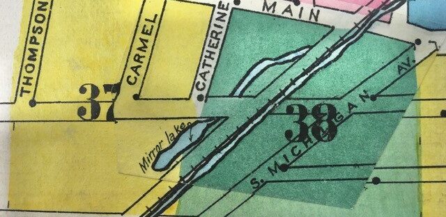 1908 Sanborn Fire Insurance Map
Morrow Lake
A reservoir on the Kalamazoo River in Comstock Township lying east of Comstock and west of Galesburg between M-96 on the north and I-94 on the south. At approximately 1000 acres (estimates vary), it is three miles long, a mile wide at its widest point and, on average, 17 feet deep. It formed after the 1939 construction of Morrow Dam on its west end, which supplied cooling water to Consumers Power Company’s Bryce Morrow Power Station. Bryce Morrow was an electrical engineer who had headed the electric production and transmission department for many years before his death in 1936. Sometimes known as Kilowatt Lake, it is also used for recreation. River Oaks County Park lies on its northern shore (KG 7/12/1964; KG 11/8/1939; KG 6/13/1971).
Morton
see Galesburg
Murry Lake
A small lake in section 9 Alamo Township. Pine Creek runs through it. Irish immigrant Patrick Murray and his family farmed land on the northeast side of the lake for most of the last half of the 19th century. (1916 topo map, Kalamazoo Quadrangle; 1855 plat map; 1873 county atlas; 1890 county atlas)
Nazareth
A hamlet northwest of the corner of Gull and Nazareth Roads on the northeast boundary of the city of Kalamazoo. So named because it was the location of the motherhouse (also college and academy) of the Sisters of St. Joseph. St. Joseph lived in Nazareth in Galilee. It was given a post office in 1899, which for more than 100 years remained a popular place from which to postmark Christmas cards. (Romig, p.389; Malcolm, pp.255-257)
Oakwood Lake
see Woods Lake
Oshtemo
Both a village and a township. The township is on the west border of the county, directly west of Kalamazoo. The village is centered at the intersection of 9th Street and Stadium Drive. Oshtemo is an Indian word meaning head waters. The township was established in 1838-39; the village was granted a post office in 1857. It became a charter township in 1979. Originally the area was largely agricultural, but is now predominantly a residential suburb of Kalamazoo. Among the pioneers in the southeast corner of the township were Enoch Harris and his family, the first black settlers in the county. (Romig, p.421; 1916 topo map; Vogel, pp.84-85; township website)
Paragon Prairie
see Toland’s (sometimes Tolland’s) Prairie
Parchment
 Jacob Kindleberger
A small “company town” in sections two and three of Kalamazoo Township on the east side of the Kalamazoo River. Founded in 1909 when Jacob Kindleberger built the Kalamazoo Vegetable Parchment Company, a paper mill, from which the town drew its name. Kindleberger wanted to ensure the success of his company by providing his employees with a place to live in addition to a place to work. His efforts drew national attention. Incorporated as a village in 1931, it became a city in 1938. Eventually, the company changed ownership several times, but ceased operations altogether in 2000. Parchment is still a pleasant town working to change its focus in life. For a fuller discussion of its history, see our web page Parchment: The paper city. (1916 topo map; Romig, p.428 )
Parsons’ Corners
see Texas Corners
Pavilion, or Pavilion Post Office
A hamlet at the intersection of 34th Street and S Avenue in Pavilion Township, more commonly known as McKain’s Corners. The name Pavilion reportedly came from Pavilion, Genesee County, New York, from whence came Ruel Starr, an early resident who apparently did not stay there long. It shows as Pavilion in the 1873 atlas and the 1918 topo map, but along S Avenue in sections 27 and 34 in the 1890 atlas. The former location is most likely because the post office was there. The latter is probably a mistake and should have been Indian Lake Station. The intersection of the railroad, R Avenue and 34th Street is known by its railroad name Pavilion Junction (Romig, p.432; Durant, p.423; Meints, p.176)
Pavilion Township
Located southeast of the central point of the county, bounded by Comstock Township on the north, Cimax Township on the east, Brady Township on the south and Portage on the west. Organized from Brady Township in 1836, and included Portage Township until 1838 and named for the hamlet of Pavilion. (Durant, p.417)
Pikes Pond
This small pond can be found driving along Edgemoor Avenue, just south of the Kleinstuck Preserve. The name likely derives from Samuel Pike, a British-born farmer and stone mason who owned nearby land in 1873.
 Pleasant Valley UMC
Pleasant Valley
A “gentle depression” in southern Prairie Ronde Township. Pleasant Valley School was located in Section 29 between XY Avenue and Y Avenue. There is still a Pleasant Valley United Methodist Church in the same area. (Durant, p.435; current topo map, Schoolcraft Quadrangle)
Pomeroy
A station in section 21 of Pavilion Township at the intersection of the Grand Trunk Western Railroad, and QR Avenue between 28th and 29th Streets. There was probably not much of a settlement there, since it does not show on the 1910, 1913 or 1928 atlases, although a 1961 AAA map shows it reversed with the location of Kealey (1918 topo map; Meints, p.176).
Portage
The city and township of Portage are nearly congruent. The township lies southwest of the center point of the county, bounded by Kalamazoo Township on the north, Pavilion Township on the east, Schoolcraft Township on the south and by Texas Township on the west. The area was first settled in 1830 and given a post office as Sweetland in 1836. It was set off from Pavilion Township in 1838 and named for its main waterway, Portage Creek. The southern half of the township drains into the St. Joseph River, the northern half into the Kalamazoo River. In pioneer times when roads were poor, being able to portage easily from one watershed to the other would have been an advantage, so it is no surprise that early settlers would have named their new home after the natural convenience it offered them. The post office was renamed Portage in 1839. Home to Pfizer (formerly the Upjohn Company) and Celery Flats, a recreational and historical area, the Air Zoo Aerospace and Science Experience, and a large commercial strip. After a dispute with Kalamazoo, which wanted to annex the Upjohn Company manufacturing plant, Portage was incorporated as a city in 1963 and covers the same area as the township with the exception of a few parcels on the north edge which are part of the city of Kalamazoo, the largest of which is the site of the Kalamazoo/Battle Creek International Airport. (Romig, p.452; Durant, pp.427, 431; Potts, pp.112-113)
Portage Creek
Portage Creek “rises in the township of Charleston, flows southwest, then south and empties into Indian Lake. Continuing its course through the township of Brady, it flows into St. Joseph County, where, with other streams, it forms the Portage River.” (Durant, p.417)
Potter’s Lake
see Climax Prairie
Prairie Ronde
 Olympia Brown
Lucius Lyon, an early surveyor, described it as “a high and fine, rich and beautiful prairie containing about 20,00 acres….” The largest of the county’s prairies, it is actually closer to 13,000 acres and lies mostly in Prairie Ronde and Schoolcraft Townships with the northern tip extending into Texas Township and the southern end into St. Joseph County. The name is French for “round meadow,” although it is clearly not round in shape. In its center is a wooded area commonly known as “the Big Island.” Prairie Ronde was the birthplace of Unitarian minister and woman suffragist Olympia Brown. (Mich. Hist. 31:31; Durant, p. 58; Presettlement map)
Prairie Ronde Township
The southwestern-most township in Kalamazoo County. It was set off from Brady Township in 1836 and named for Prairie Ronde, its most prominent geographical feature. The first white settlers in the county, Bazel Harrison and his family settled in the township near Harrison Lake in 1828. (Durant, pp.436, 449)
Prospect Hill
The large hill found east of Oakland Drive and west of Davis Street, where Western State Normal School established their campus in 1903. The earliest use of the name in the Kalamazoo Gazette goes as far back as the mid 1850s.
Richland
 First Presbyterian Church
Centered at the intersection of North 32nd Street and D Avenue and just east of where Gull Road, originally an Indian Trail across Gull Prairie, enters the village. In early years it was known as Gull Corners, and sometimes as Richland Center. Renamed for its township, probably when it was incorporated as a village in 1871, it comprises one square mile at the corners of sections 14, 15, 22 and 23. Many of the early settlers were New England natives; a New England style village green is still a prominent feature of the village. Several businesses were established there in the early 1830s, and the First Presbyterian Church was built on the green in 1837. The post office, originally granted to nearby Geloster, was moved to Gull Corners in 1840. For additional information, see our Richland web page. (Durant, p.469)
Richland Center
see Richland
Richland Junction
A hamlet in section 8 Richland Township near 28th Street and Richland Drive. It was at the junction of the Chicago, Kalamazoo & Saginaw and Michigan Central Railroads (the latter named in some sources as the Grand Rapids & Indiana or the Detroit, Toledo & Milwaukee). There is a plat of it in the 1910 atlas. (1910 atlas; 1918 topo map, Romig, p.474; Meints, p.176)
Richland Township
In the northern tier of townships, bordered on the west by Cooper Township and on the east by Ross Township. Set off as a separate township from Arcadia in April 1833, it was named by early settlers for the high quality of its soil. (Durant, p.457)
Rix, or Rix Station
Once a station on the Kalamazoo, Lake Shore & Chicago Railroad at the intersection of South 4th Street and the tracks, a half-mile north of West ‘O’ Avenue in Texas Township. Named for the pioneering Rix family, brothers Ira, Johnson and George. For further history, see our web page. (Romig, p.479; 1918 topo map)
Rocky Creek
Durant says of it, “The principal watercourse of [Prairie Ronde] township…which flows in a gentle depression known as ‘Pleasant Valley.’ The general course of the stream is southeast, and it furnishes considerable water-power.” It does not appear on maps by that name, but is likely an early name for Flowerfield Creek, which does flow southeast and certainly qualifies as the main watercourse of the township. (Durant, p.435; topo maps Schoolcraft Quadrangle).
Ross Centre
The exact location in Ross Township is unclear. There was a post office in Ross Centre in 1844; John Van Vleck was the first postmaster there. Romig states that “the office was changed to Yorkville on April 9, 1845.” Since Van Vleck owned land in section 21, which is nearer the center of the township than Yorkville, it seems likely that Ross Centre was there, rather than being an earlier name for Yorkville. (Romig, p.486; Durant, pp. 487 and 489-90; BLM-GLO)
Ross Township
The northeastern most township in Kalamazoo County. Set off from Richland Township in 1839, the origin of the name is unknown. Primarily a rural area, but home to the Gilmore Car Museum, Ft. Custer Recreation Area, the Barn Theatre, part of Gull Lake, and the village of Augusta. (Durant, p.486)
Rowe’s Island, or Rowe Island, or Roe Island
An island in the Kalamazoo River (where it now forms Morrow Lake) between Comstock and Galesburg, in section 22 Comstock Township. Early mentions call it Roe’s Island, although more recently it is spelled Rowe’s. The 1873 and 1890 atlases show the owner as J. E. Roe, possibly Joseph Roe, who was listed in the 1880 census in Comstock Township. It was the site of a well-preserved Indian garden bed. (1873 atlas; 1890 atlas; Durant, p. 366; KG 11/25/1930)
Schoolcraft
A village in sections 18 and 19 of what is now Schoolcraft Township, situated on the eastern edge of the “Big Island,” a wooded area of several hundred acres in the middle of Prairie Ronde. It was surveyed by Stephen Vickery for the proprietor, Lucius Lyon, who named it for his friend Henry Rowe Schoolcraft, Michigan’s Indian Agent. The original plat was recorded in October 1831. Incorporated as a village in 1866, it is best known now for being the site of the home of Quaker physician Nathan Thomas and his wife Pamela who conducted a station on the underground railroad in the years before the Civil War. For additional information about Schoolcraft, see also our website. (1890 atlas; Mich. Hist. 31:31; Durant, p.502-532; Romig, p.502)
 Nathan Thomas’s Underground Railroad House, Schoolcraft
Schoolcraft Township
Lies on the southern border of the county between Prairie Ronde Township on the west and Brady Township on the east. Set off from Brady Township in 1842 and named for the village of Schoolcraft which was, in turn, named for Henry Rowe Schoolcraft, Michigan’s Indian Agent. About half the land area is occupied by a large part of Prairie Ronde and all of Gourdneck Prairie. It is home to the villages of Schoolcraft and Vicksburg, Prairie View County Park and the Gourdneck State Game Area. (Durant, p.502; Presettlement map)
Scotts, or Scotts Crossing
An unincorporated community in section 24 Pavilion Township and Section 19 Climax Township. Land there was originally deeded from the U. S. government to Dan Wheeler in 1835. Samuel Scott settled there in 1847, when the community became known as Scotts Crossing, later shortened to Scotts. A post office named Scotts opened on February 19, 1872. Servetus Bathrick served as its first postmaster and platted the settlement in 1874. (Romig, p.503)
Shirland
A village in section 25 of Prairie Ronde Township that was platted and registered in 1831 by Christopher Bair, William Duncan, Samuel Hackett, John Insley, and Edwin Kellogg. Possibly named for pioneer John Shirley. It was never developed, but the site was located at what is now the intersection of South 11th Street and West XY Avenue. Shirland School was located at that intersection for many years. (Durant, p.447; Romig, p.513).
Stevens Corners
The intersection of Oakland Drive and Parkview Avenue at the northeast corner of section 32, Kalamazoo Township (now inside the city limits). Early settlers Isaac Stevens and his son Andrew Jackson Stevens lived in that section for many years. The latter’s Greek Revival home still stands at 4024 Oakland Drive.
Sweetland
see Portage
Texas Corners
Named for its township, it is the unincorporated commercial center of the township at the conjunction of 8th Street, Texas Drive and Q Avenue. Formerly known as Parsons Corners, after Nelson Parsons, who farmed more than 100 acres at that intersection. It first appears as Texas Corners on the 1890 plat map of the county, although it was probably known that way after a post office was established there in 1874. (1890 atlas; 1918 topo map; KG 7/29/1880; Romig, p.552)
Texas Township
A charter township located on the west border of Kalamazoo County, between Oshtemo Township on the north and Prairie Ronde Township on the south. It was set off from Brady Township in 1838 and named for the state of Texas “for the Texas revolt from Mexico was considered as a victory for free men over tyranny.” It was primarily agricultural until 1957 when I-94 was constructed. The interchange at 9th Street spurred commercial and residential development. Al Sabo Land Preserve and the main campus of Kalamazoo Valley Community College are both located there. (Romig, p.552; Durant p.536; township website)
Toland’s (sometimes Tolland’s) Prairie
Five hundred acres on the west edge of Galesburg in Comstock Township. The earliest settlers called it Paragon Prairie. William Toland was the first settler in 1829, although he didn’t stay long. Also called Matthews Prairie after a later settler Nathaniel Matthews, and on one early map, Fry Prairie. (KG 7/9/1929; Presettlement map; Durant, p.351; Romig, p.557)
Travis, or Travis Station
A flag station on the Grand Rapids & Indiana Railroad in section four of Cooper Township on land owned by D. D. Travis (probably Daniel) (Romig, p.560; Meints, p.176; 1873 atlas; 1890 atlas).
Trout Run
see Cooper’s Glen
Vicksburg
 Spiritualist meeting, 1895
A village in the southern part of the county straddling the line between Schoolcraft and Brady Townships and lying between Sunset Lake on the north and Barton Lake on the south. John Vickers, for whom the town was eventually named, established what is believed to be the first gristmill in the county. The dam that he created on Portage Creek to power the mill formed Sunset Lake. It was a station on the Grand Rapids & Indiana Railroad in 1867, and incorporated as a village in 1871. Beginning in the late 1800’s it was known as a center of the spiritualist movement and hosted camp meetings every summer for many years. Lee Paper (later Simpson Paper) was the major industry there for most of the 20th century. For a more detailed history, see our web page. (Romig, p.573)
Virginia Corners
The intersection of Oakland Drive and U Avenue in Schoolcraft Township on the east edge of Prairie Ronde. Settled in the fall of 1830 by Aaron Burson, his sons and several others who were originally from Virginia. There is now (2020) a plat on the northwest corner of that intersection known as Virginia Downs. (Durant, p.504; orally in 1987 from several residents of the area)
Wakeshma Centre
see Fulton
Wakeshma Township
 Dr. Homer Stryker
The southeastern-most township in Kalamazoo County. It was organized in 1846, the last of the townships to be set off from Brady Township, which had previously encompassed the whole southern half of the county. Its name is probably a corruption of Ojibwa and Potawatomi words meaning “it is shining.” Largely rural, its only population center is the unincorporated community of Fulton, which has also sometimes been called Wakeshma Center. Dr. Homer Stryker, inventor, orthopedic surgeon and founder of what is now Stryker Corporation was born and raised in Wakeshma Township. (Vogel, p.148: Durant, p.544)
Walker, or Walker’s Crossing, or Walker Station
Located on West ‘O’ Avenue, a half-mile west of 4th Street where it intersected with the Kalamazoo, Lake Shore & Chicago Railway on the southern corner of Robert Walker’s farm in Texas Township. For additional information, see our web page (1918 topo map).
Williams, or Williams Crossing, or Williams Station
 A settlement in sections 29 and 30 along 2nd Street in Alamo Township. Founded by the Chester A. Williams family who came here from New York State in 1854. It was once a bustling stop on the Kalamazoo and South Haven Railroad (later Michigan Central). After the railroad abandoned it in the 1970s, it became a ghost town. For additional history, see our Williams web page. (Romig, p.604; 1916 topo map).
 George Winslow
Winslow’s Island, or Winslow Island
An island in the Kalamazoo River in section 10, Kalamazoo Township, across from Riverside Cemetery. Although it no longer exists, it was once a popular picnic spot. At one time it belonged to early businessman George W. Winslow, who owned the marble works. Late in his life he became interested in spiritualism and designated in his will that “Winslow Island in the Kalamazoo River be made available ‘free and without charge’ for ‘all meetings of spiritualists, for temperance meetings and pic-nics’ without regard to denomination….” (1890 atlas; Museography, 2005)
Wintergreen Lake
About 40 acres in section 8 of Ross Township on the grounds of Kellogg Bird Sanctuary. it has a maximum depth of 21 feet.
Woods Lake
In section 29 of Kalamazoo Township, just northwest of the intersection of Oakland Drive and Parkview Avenue. Named for pioneer settler Smith L. Wood, for many years it was the site of Oakwood Amusement Park, a popular attraction at the end of the streetcar line. Today it is bordered on the east by a city park with homes surrounding the remainder of the lake. The lake was called Bragg’s Lake as far back as the 1860s, when Leonard Bragg owned a nursery on the lake’s north shore. It has also been known as Oakwood Lake and Lakeview Lake.
An unincorporated settlement, mostly in section 19 of Ross Township at the outlet of Gull Lake. First settled in 1833 by Tillotson Barnes who presumably named it for the town of Yorkville in Oneida County, N. Y., from which county he came. He established both a saw-mill and a grist-mill there. Until 1920 it was a station on the Detroit, Toledo & Milwaukee Railroad. There was a post office there from 1845 until 1939. (Romig, p.617; Durant, p.501)
Compiled by Catherine Larson, Kalamazoo Public Library staff, with thanks to all the people who contributed bits of information over the years, and to Keith Howard for technical help. Page launched 5 August 2021. Last updated 25 February 2026.
Sources
Books
Alamo Township, most northwest corner of Kalamazoo County, Michigan: past and present, 1958
Florence Snow
H 977.417 S67
Along the tracks: A directory of named places on Michigan railroads
Graydon Meints
Mount Pleasant, Michigan: Clarke Historical Library, Central Michigan University, 1987
H 385 M514.4
As you were: Fort Custer
Faye Clark
Galesburg: Kal-Gale Printing, 1985
H 977.422 C592
Gull Lake, Michigan: an ideal place for a summer vacation
C. E. Cleveland, 1904
64 page booklet in History Room Subject File: Gull Lake
Historical directory
Robert Eugene Meader
H 920 M481, 36 volumes
History of Allegan and Barry counties, Michigan : with illustrations and biographical sketches of their prominent men and pioneers
Evansville, Indiana : Unigraphic, Inc. 1975 (indexed edition)
Reprint of the edition published by D. W. Ensign & Co., Philadelphia, 1880
History of Kalamazoo County, Michigan: with illustrations and biographical sketches of the prominent men and pioneers
Samuel W. Durant
Evansville, Indiana : Whipporwill Publications
Reprint of the edition published by Everts & Abbott, Philadelphia,1880
If only the walls could talk: The architectural heritage of Cooper, Michigan
W. Ward Christlieb
Allegan Forest, Michigan: The Priscilla Press, 2000
H 977.417 C555
Indian names in Michigan
Virgil J. Vogel
Ann Arbor: University of Michigan Press, 1986
H 917.74 V879
Michigan pioneer collections
Lansing: various publishers and dates, 40 volumes
H 977.4 M62
Michigan place names
Walter Romig
Great Lakes Books, 1986
H 917.74 R765W
Portage and its past
Grace Potts
Portage, Michigan: Portage Public Schools and the City of Portage Public Library, 1976
H 977.417 P871
Portrait and biographical record of Kalamazoo, Allegan and Van Buren Counties, Michigan
Chicago: Chapman Bros., 1892
H 977.41 P85
Unknown America
Andrew H. Malcolm
Quadrangle/The New York Times Book co., 1975
Articles
“Death of Thos. C. Brownell”
Kalamazoo Gazette, 25 March 1879, page 4, column 2
“Texas” [death of Nelson Parsons]
Kalamazoo Gazette, 29 July 1880, page 4, column 3
“Lake View Park”
Kalamazoo Gazette, 11 July 1893, page 1, column 3
“Oakwood Park is the name”
Kalamazoo Gazette, 27 February 1907, page 8, column 3
“C. T. S. Cook passes”
Climax Cereal, 20 June 1912, page 5, column 2
“Grand dad had better slides right here in Kalamazoo than have kids of 1919 A.D.”
Kalamazoo Gazette, 2 March 1919, page 17, column 3
“Fruit juices manufactured on big scale”
Kalamazoo Gazette, 18 October 1925
Copy in the History Room Agriculture scrapbook, volume 1, page 2
“He has 1835 map showing Kazoo as ‘Bronson Mills’ ”
Kalamazoo Gazette, 28 March 1921, page 8, column 2
Copy available in Roads – Kalamazoo scrapbook, volume 1, page 5
“Lake’s silent shores hold exiled nobleman’s secret”
Kalamazoo Gazette, 11 July 1926, page 14, column 7
Copy available in the Kalamazoo Scrapbook, volume 7, page 7
“Prairies or natural meadows of Kalamazoo County totaled 21,100 acres”
Kalamazoo Gazette, 9 July 1929, page 13, column 3
Copy available in Kalamazoo Scrapbook, volume 1, page 4
“Well-preserved Indian garden beds found on island in Kalamazoo River”
Kalamazoo Gazette, 25 November 1930, page 3, column 4
Copy available in Kalamazoo County scrapbook, volume 5, page 12
“Historical markers and memorials in Michigan”
Compiled by Percy H. Andrus
Michigan History, volume 15, Spring 1931, page 249
“Fully protect public, demand of death jury”
Kalamazoo Gazette, 7 January 1937, page 1, column 7
“Gazette’s Historical Scrapbook: Few now recall ….”
Kalamazoo Gazette, 14 February 1938, page 8, column 4
“Factory that made but 1 jug gave Jug Corners name”
Kalamazoo Gazette, 31 July 1938, page 28, column 5
Copy in Kalamazoo County scrapbook, volume 3, page 2
“Dedicate new Morrow Power Station today”
Kalamazoo Gazette, 8 November 1939
Copy available in Public Utilities scrapbook, volume 7, page 6
“Rediscovering Michigan’s prairies”
Michigan History, 1947, volume 31, page 279
“Cooper, Lyon and the Moore-Hascall harvesting machine”
Michigan History, March 1947, volume 31, pages 30-31
“Move Burson 114-year-old family home”
Kalamazoo Gazette, 11 Sept 1955, page 15, column 1; copy available in the Michigan – Roads Scrapbook #1.
“Small but unique: Morrow Dam here has a special purpose”
Kalamazoo Gazette, 12 July 1964
Copy available in Public Utilities scrapbook, volume 10, page 5
“Vanished village; Geloster even flopped as a ghost town”
Kalamazoo Gazette, 20 August 1964, page 29, column 1
Copy available in Kalamazoo County scrapbook, volume 7, page 20
Robert B. Cook obituary
Kalamazoo Gazette, 27 December 1967, page 36, column 6
“ ‘Static’ Kilowatt Lake transforming: 332,000 walleyes planted”
Kalamazoo Gazette, 13 June 1971, page B10, column 1
“What’s in a name? A little slice of history”
Kalamazoo Gazette, 8 July 1984, page D1, column 1
“Lemon Park was the place to go for the sweet taste of summer”
Kalamazoo Gazette, 27 September 1987, page B9, column 1
Copy available in the History Room Subject File: Lemon Park
“Portage bog offers escape to nature”
Kalamazoo Gazette, 30 May 1988, page B1, column 5
“Suburb in the city: old and young find homes in Kalamazoo’s Milwood”
Kalamazoo Gazette, 23 April 1989, page C1, column 1
“Marvelous Milwood”
Kalamazoo Gazette, 8 June 1997, page G1, column 1
“A touch of the north; Bishop’s Bog Trail provides U.P. flavor just outside Kalamazoo”
Kalamazoo Gazette, 2 May 1998, page B1, column 2
“Grazing through history with Kalamazoo’s Tillers”
Kalamazoo Gazette, 28 April 2003, section 2, page 6, column 4
“Island legacy; former appeals judge leaves river land to conservancy”
Kalamazoo Gazette, 28 October 2003, page E1, column 2
“Chipman Preserve dedicated”
Kalamazoo Gazette, 26 September 2004, page B1, column 1
“Summer fun: lake resorts in Kalamazoo County”
Museography, Summer 2005, volume 4, pages 14-15
“Spiritualism in southwest Michigan: voices from the great beyond”
Museography, Fall 2005, pages 10-11
Local History Room Files
The community of Milwood
Undated pamphlet, no author or publisher
Subject File: Milwood
Maps and atlases
Chad Maps, Kalamazoo County, Michigan, Plat Book
Edited, published, & indexed by Chad Maps, Inc., 1601 Portage Street, Kalamazoo, Michigan 49001
Housed on top of History Room Atlas Case
USGS topographic maps for Kalamazoo County, 1916, 1918 (various quadrangles)
See History Room map index for exact locations.
Map of Kalamazoo County
ca1855 (reprinted by Kalamazoo Public Museum in 1980)
Grand Rapids, Michigan: Robert S. Innes
Atlas of Kalamazoo Co., Michigan…
New York: F. W. Beers & Co., 1873
H 912.77417 K14 (Spine title: Combined atlases of Kalamazoo, Michigan 1873, 1890)
History Room Atlas Case, Left Shelf #1
Illustrated atlas of Kalamazoo County, Michigan
Detroit: Wm. C. Sauer, 1890
H 912.77417 K14 (Spine title: Combined atlases of Kalamazoo, Michigan 1873, 1890)
History Room Atlas Case, Left Shelf #1
Standard atlas of Kalamazoo County, Michigan
Chicago, Illinois: Geo. A. Ogle, 1910
History Room Atlas Case, Left Shelf #1
Also available on microfilm: County and Regional Histories of the Old Northwest
H Microfilm Reel 45, Item 135
Atlas of Kalamazoo County, Michigan
Chicago: H. C. Maley, 1913
History Room Atlas Case, Left Shelf #1
Plat book of Kalamazoo County, Michigan/compiled from surveys and the public records of Kalamazoo County, Michigan
Glen C. Wheaton
Rockford, Illinois: Thrift Press, Map Makers, c1928
History Room Atlas Case, Left Shelf #1
Presettlement vegetation map of Kalamazoo County, Michigan
Thomas W. Hoder, Richard Brewer and Henry A. Raup
Western Michigan University, 1981
Sheet map, Left drawer #1
Websites
Bureau of Land Management, General Land Office Record
Click “Search documents”
Military History of the Upper Great Lakes