Brighton, Rix, Walker, & Eassom
Long Lost Stations on “The Fruit Belt Line”
 The Kalamazoo, Lake Shore & Chicago Railway (KLS&C) was a short-lived railroad known as “The Fruit Belt Line” that ran between Kalamazoo and South Haven during the first decades of the 20th century. The KLS&C followed a southerly route through the communities of Oshtemo, Mattawan, Lawton, Paw Paw, Lawrence, and Hartford. But the train also stopped in places along the way that are perhaps not so familiar, places like Brighton, Rix, Walker, and Eassom. Those locales have long since vanished from today’s maps but a little over a century ago, they were rural railroad “flag stops” alive with activity and important hubs of agricultural commerce in southwestern Kalamazoo County.
 Rail Road Lines in Western Kalamazoo County, c.1910. Rand McNally
Kalamazoo, Lake Shore & Chicago Railway
In 1906, Kalamazoo based fruit and produce magnate Samuel J. Dunkley purchased an abandoned section of the Michigan Central Railroad line between Kalamazoo and Mattawan with plans to establish an electric interurban line between Kalamazoo and his company’s boat docks in South Haven. Dunkley’s electric line never materialized, but he did manage to get a small steam road up and running between Kalamazoo and Paw Paw by May 1906. With a used locomotive and a couple of secondhand passenger cars, the Kalamazoo, Lake Shore & Chicago Railroad was born. Within a year’s time Dunkley had his passenger line with expanded freight service open through to South Haven.
 Kalamazoo, Lake Shore & Chicago Railway Directory 1913-14. Note the four additional stops between Oshtemo and Mattawan.
From its passenger and freight depot near downtown Kalamazoo, the KLS&C traveled west to Oshtemo and on through small but important stopping places (“flag stops”) on the road toward South Haven. Brighton (or Brighton Crossing), Rix (also known as Rix Station), Walker (Walker’s Crossing), and Eassom (or Eassom Station) were all places where mail bags were exchanged, commuters waited for the next train into town, and farmers loaded baskets filled with potatoes, melons, apples, tomatoes, peaches, and berries onto freight cars bound for Dunkley’s canning factories or the open produce markets.
Brighton (Brighton Crossing)
After departing Oshtemo, the train made its next stop two miles down the line at a place called Brighton. Not to be confused with the city by the same name on the east side of the state, Brighton (also called Brighton Crossing) was located southwest of Oshtemo where the KLS&C crossed South 6th Street near West ‘N’ Avenue at the Texas Township line.
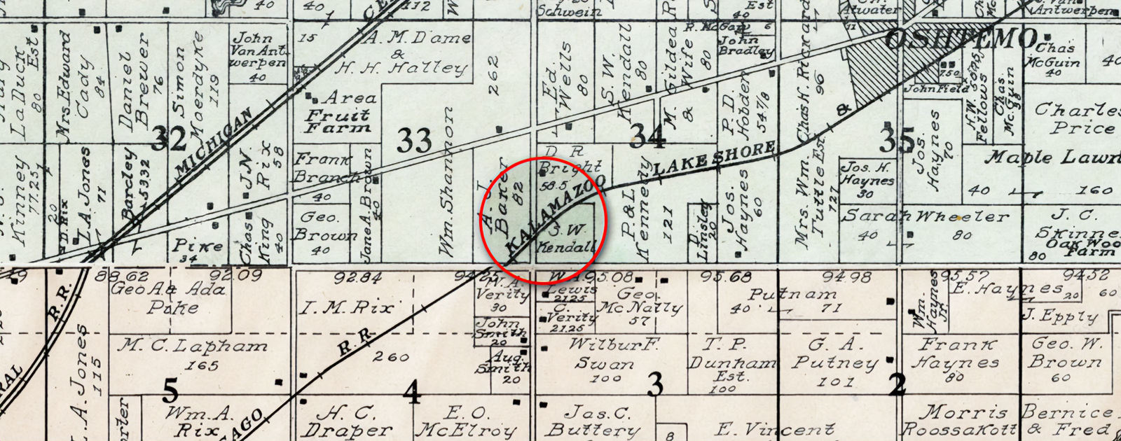 Brighton Crossing at South 6th Street near the Oshtemo/Texas Township line. Geo. A. Ogle & Co., 1910.
David R. Bright
Brighton was evidently named for David R. Bright, a Civil War veteran and award-winning local farmer who hosted the aptly named rail stop on his property along the north side of the KLS&C tracks east of South 6th Street. D.R. Bright was an active political figure in the Dakota Territory after the war before moving to Kalamazoo in the late 1870s. Six years later, Bright and his wife relocated to Oshtemo where he became a successful farmer and served as justice of the peace. Bright’s flower gardens were said to be “magnificent” and were “visited each summer by many from the city” (Gazette).
As the train approached Brighton Station from the east the line curved southward and crossed 6th Street at a rather steep angle below the crest of a hill. This created a dangerous blind intersection often referred to as a “death crossing.” In May 1919, the sandy intersection at Brighton Crossing did indeed prove deadly for a rural mail carrier from Oshtemo when he failed to see the oncoming KLS&C locomotive before it struck his vehicle.
An active member of the Grand Army of the Republic (G.A.R.), David Bright was among Kalamazoo’s thirty-nine remaining Civil War veterans who took part in the 1923 Memorial Day services. Bright passed away later that year in October at the age of 89, one year before the KLS&C line was discontinued.
 Brighton Crossing location as it appears today (looking northeast). Railroad line followed the path on the right.
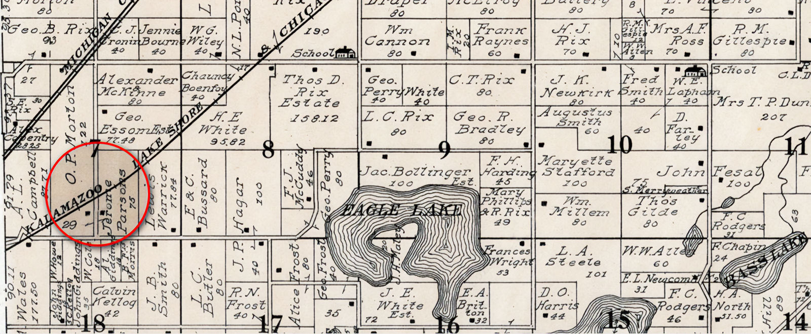
Rix (Rix Station)
Continuing southwest from Brighton, the train made its next stop where the railroad crossed a portion of the Rix family farm in Texas Township. Known commonly as Rix Station, the rail stop was located where the KLS&C tracks crossed South 4th Street, a half-mile north of West ‘O’ Avenue. Tiny as it was, Rix had all the makings of a small village with a post office, a grocer, a school, and a railroad depot.
 Rix at the South 4th Street crossing in Texas Township. Geo. A. Ogle & Co., 1910
Ira, Johnson, and George Rix
Rix was named for brothers Ira, Johnson, and George Rix who were among the earliest white settlers to arrive in Texas Township. During the 1830s George became a township assessor, supervisor and justice of the peace. Johnson Rix was an early highway commissioner and director of the poor. Future generations followed as Thomas D. Rix later became a prominent Texas Township supervisor.
“There are many places that would be benefited by the placing of a mail car on the Fruit Belt road, and the residents along it hope that favorable action will be taken by postal authorities.”
—Kalamazoo Gazette, 12 September 1907
The main township post office was located in Texas Corners, but a second township post office called “Rix” was established in 1897 on the Rix family property along the Michigan Central line. Ernest E. Annabel was the first postmaster there, succeeded the following year by grocer Helen C. Gunn. The post office in Rix remained open on the Michigan Central line until 1901. Mail service between Kalamazoo and Lawton returned in 1907 when a regular mail car was added on the newly opened KLS&C line.
The community of Rix continued to grow and by 1870, area students were attending school at Fractional District No. 6 and District No. 12 schoolhouses, both of which were located on Rix family property. The District No. 12 schoolhouse–commonly known as Rix School–was located on the Thomas Rix property at the northwest corner of West ‘O’ Avenue and 4th Street just south of the railroad line. Fractional District No. 6 was known as Oak Grove but in later years called Rix School for landowner Daniel Rix, Jr. The building still stands in Section 6 at the northwest corner of Stadium Drive and 1st Street.
Through the years several members of the Rix family worked as teachers in the Rix schools and each year in the springtime, students, alumni, teachers, families, and friends gathered at the No. 6 schoolhouse for a school reunion picnic. Nearly 300 attended the 1910 reunion, which required a wagon with a four-horse team to transport attendees back to the train depot for the return trip to Kalamazoo. Both schoolhouses near Rix remained in service until the Second World War.
Walker (Walker’s Crossing, Walker Station)
After leaving Rix, the train traveled another mile past orchards and farmland on the way to its next stop at Walker. The Walker rail stop was located on West ‘O’ Avenue, a half-mile west of 4th Street on the southern corner of Robert Walker’s farm.
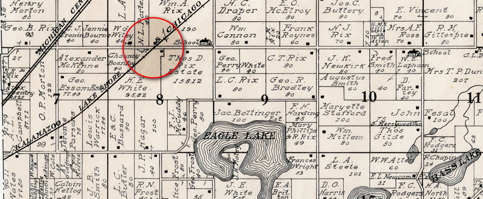 Walker Station at the West ‘O’ Avenue crossing in Texas Township. Geo. A. Ogle & Co., 1910
Robert Walker
Born in 1829 in his native Scotland, Robert Walker was living in the village of Kalamazoo when he was called into service during the Civil War. After the war he moved his family to the former George Eller property in Texas Township, where they remained until Robert’s death in 1907. Years later when William Sanders acquired the former Walker farm, he discovered the old depot building, which had been used as a chicken coop. Sanders converted the building into a playhouse for his kids.
Eassom (Eassom Station)
A mile past Walker, the train made one additional stop before reaching the village of Mattawan. Eassom (or Eassom Station) was located on South 1st Street, a third of a mile north of West ‘P’ Avenue near the farms of Robert and Edwin Eassom.
 Eassom Crossing at South 1st Street in Texas Township. Geo. A. Ogle & Co., 1910
Robert, Edwin, and George Eassom
The Eassoms where well-known family farmers who emigrated from their native England and settled in Texas Township during the 1850s. Ed and Robert both registered to serve during the Civil War and both maintained productive farms in Texas Township until 1880 or after. Edwin Eassom died in 1903, Robert in 1905. Ed’s son George later served as a township constable and justice of the peace before his death in 1909.
 KLS&C railroad grade looking northeast from 1st Street where Eassom Station was located.
After taking on passengers and freight at Eassom Station, the train continued into Van Buren County through Mattawan, Lawton, and eventually on to South Haven. By 1920, Eassom Station was no longer shown on the map and had presumably been discontinued as a stop on the KLS&C line.
Fruit Belt Trail
After years of declining ridership the Fruit Belt Line was closed down in November 1924 and the tracks were removed the following year. Today the portion of the old KLS&C railroad bed between Oshtemo and Mattawan is used for underground telecommunication lines and as an informal walking trail. As of early 2020, developers were proposing an improved walking path to be called the Fruit Belt Trail that would begin at Flesher Field off of 9th Street and follow the old railroad bed to the southern Oshtemo Township line and perhaps beyond.
Written by Keith Howard, Kalamazoo Public Library staff, April 2020.
 A portion of “The Fruit Belt Trail” near Oshtemo, April 2020. Photo by Keith Howard
Sources
Books
History of Kalamazoo County, Michigan : with illustrations and biographical sketches of its prominent men and pioneers.
Samuel W. Durant
Philadelphia: Everts & Abbott, 1880.
R 977.417 H67W
Next Stop Kalamazoo! : A history of railroading in Kalamazoo County.
David C. Hager
Kalamazoo Public Museum, 1976
H 385 H144
Michigan Place Names: The History of the Founding and the Naming of More Than Five Thousand Past and Present Michigan Communities
Walter Romig
Wayne State University Press, 1986
H 917.74 R765W
Articles
“Among the dead – Thomas D. Rix”
Kalamazoo Gazette, 10 February 1898, page 1, column 6
“Obituary. Thomas D. Rix”
Kalamazoo Gazette, 25 February 1898, page 1, column 4
“Their Golden Wedding Day”
Kalamazoo Gazette, 3 January 1904, page 5, column 1
“Regular Train Service Tomorrow”
Kalamazoo Gazette, 4 May 1906, page 8, column 4
“Mail Service For Fruit Belt Line”
Kalamazoo Gazette, 12 September 1907, page 3, column 4
“Alert Farmers Have Show At Texas Corners”
Kalamazoo Gazette, 11 November 1908, page 1, column 6
“George W. Eassom”
Kalamazoo Gazette, 11 April 1909, page 1, column 6
“Bright Family Reunion”
Kalamazoo Gazette, 20 August 1909, page 5, column 2
“Home Coming Picnic At Rix School House”
Kalamazoo Gazette, 24 May 1910, page 3, column 2
“M.U.R. Secures Fruit Belt Line”
Kalamazoo Gazette, 20 April 1911, page 1, column 4
“Rural Mail Carrier Hurt At Brighton”
Kalamazoo Gazette, 27 May 1919, page 1, column 2
“Rural Mail Carrier Dies As Result Of Brighton Accident”
Kalamazoo Gazette, 28 May 1919, page 2, column 4
“No Blame For Rail Accident”
Kalamazoo Gazette, 29 May 1919, page 2, column 5
“Vet Of Civil War Succumbs”
Kalamazoo Gazette, 13 October 1923, page 9, column 2
“Remove Tracks, Ties Of Fruit Belt Railroad”
Kalamazoo Gazette, 28 August 1925, page 2, column 7
“Gone, But Not Forgotten”
Kalamazoo Gazette, 28 December 1969, page 52, column 1
“Well-Hidden Historical Fruitbelt Depot To Be Torn Down”
Kalamazoo Gazette, 26 March 1972, page 13, column 1
“New walking and biking trail proposed west of Kalamazoo”
Kalamazoo Gazette: Web Edition Articles (MI), 28 February 2020
Census Records
Johnson Rix household, 1860 United States Federal Census, Texas Township, Kalamazoo County, Michigan
Census Place: Texas, Kalamazoo, Michigan, page 157, dwelling 1149, family 1142
Online database, Ancestry Library (in library only)
Ira Rix household, 1870 United States Federal Census, Texas Township, Kalamazoo County, Michigan
Census Place: Texas, Kalamazoo, Michigan, page 24, dwelling 191, family 194
Online database, Ancestry Library (in library only)
Chauncy Bonfoey household, 1870 United States Federal Census, Texas Township, Kalamazoo County, Michigan
Census Place: Texas, Kalamazoo, Michigan, page 18, dwelling 145, family 146.
Online database, Ancestry Library (in library only)
Johnson Rix household, 1880 United States Federal Census, Texas Township, Kalamazoo County, Michigan
Census Place: Texas, Kalamazoo, Michigan, Enumeration Dist. No. 143, page 18, dwelling 172, family 180
Online database, Ancestry Library (in library only)
Census Year: 1880; Census Place: Texas, Kalamazoo, Michigan;
Archive Collection Number: T1164; Roll: 43; Page: 16; Line: 3; Nonpopulation Schedule Type: Agriculture
Online database, Ancestry Library (in library only)
Documents
“The railroad history of Kalamazoo”
Arthur Stoddard, Kalamazoo, MI. [s.n.], 1948.
H 385.09774 S867
“The Fruit Belt Line: Southwest Michigan’s failed railroad”
Graydon M. Meints, 1983.
Michigan Historical Review, Vol. 31, No. 2 (Fall, 2005), pp. 117-148
Maps
Map of Kalamazoo Co., Michigan. Philadelphia : Geil & Harley, 1861.
Library of Congress Geography and Map Division. Washington, D.C.
Call Number: G4113.K2G46 1861 .G4
Map of Kalamazoo County, Michigan. 1873.
F. W. Beers & Co., 1873
Map of Kalamazoo County, Michigan. 1890.
WM. C. Sauer, C. E., 1890
Railroad Map of Michigan, Southern Peninsula (Kalamazoo County).
Published by Rand McNally, Chicago, 1910.
Map of Kalamazoo County, Michigan. 1910.
Geo. A. Ogle & Co., 1910
Map. Plat book of Kalamazoo County, Michigan: compiled from surveys and the public records of Kalamazoo County, Michigan.
Rockford, Ill.: Thrift Press ; Kalamazoo, Mich.: Glen C. Wheaton, ?, 1928
Library of Congress Geography and Map Division. Washington, D.C.
Call Number: G1413.K2 T3 1928