Miller’s Station
Ghost Town in Western Kalamazoo County
A town called Miller, better known as Miller’s Station, was located some eight miles west of Kalamazoo where the Michigan Central Railroad line (Amtrak) now crosses West ML Avenue. Miller was once slated to replace the village of Oshtemo as a center of commerce in western Kalamazoo County. That of course didn’t happen and today, one would never know that such a place ever existed. But during the first half of the 20th century, Miller’s Station was a well-known stopping place along the Michigan Central.
 Western Kalamazoo County, c.1911. Rand McNally
Origins of Miller’s Station
Roots of the Miller community are traceable to John and Kate Miller, who settled on the west side of what would have been South 6th Street, north of West ML Avenue. Born in Baden, Germany in 1800, John Miller arrived in the United States with his wife Kate and their son John, Jr., during the German immigration flood of the 1850s. Soon after, the Millers made their home on a 40-acre parcel in central Oshtemo Township and like many area settlers, they managed to eke out a living by farming the land and producing substantial amounts of corn and wheat for their own use and for market.
During the 1860s the Millers acquired additional property south and east of their farm from neighbors Hollis Buskirk and John Ell. With these additions the Millers relocated their residence to the former Ell home on the north side of ML Avenue and closed the road between ML and KL avenues.
 Geil & Harley, et al. Map of Kalamazoo Co., Michigan. Philadelphia: Geil & Harley, 1861. Map. Library of Congress
Miller Schoolhouse
By 1872 Oshtemo Township was being touted as “the banner town of the county” with eleven schoolhouses, “seven [were] enclosed with fences, six [had] shade-trees, and six [had been] fresh painted” (Gazette). Among these was the new District No. 14 schoolhouse that stood next to the Miller home on the north side of West ML Avenue, just west of the 6th Street junction. Throughout the following three decades the District No. 14 schoolhouse not only fulfilled its purpose as a place where local kids learned reading, ‘riting and ‘rithmetic, but it served as a chapel on Sundays and as a social gathering place for the folks in south-central Oshtemo Township.
 Kalamazoo County 1890, Published by Wm. C. Sauer. Local History Room
Michigan Central Railroad
Big changes were in store for the Miller community during the first years of the twentieth century. When the old Michigan Central Railroad line (MCRR) was extended west of Kalamazoo, it originally followed a southwesterly route through the village of Oshtemo and on to Niles and New Buffalo. As freight and passenger service increased on the Michigan Central, the steep grades west of Kalamazoo became problematic. This prompted the MCRR to relocate the railroad line between Kalamazoo and Mattawan in 1905 and abandon the old portion of the road through Oshtemo Village.
The new MCRR line followed a northwesterly route out of Kalamazoo toward what is now South 9th Street, a mile-and-a-half north of Oshtemo Village. At that point the line then curved to the southwest and continued toward the village of Mattawan where it rejoined the original MCRR tracks. This new portion of the road crossed John Miller’s farm just west of the South 6th Street intersection and carved a path straight through the District No. 14 school house.
Knowing the school house would need to find a new home, third generation landowner Fred J. Miller deeded a portion of his farm to the school district in April 1904. The District No. 14 schoolhouse was then moved across the street to the southwest corner of West ML Avenue and South 6th Street to make way for the new Michigan Central line that was to open the following year.
“That village (of Oshtemo), after Sunday, will be wiped off the Michigan Central map, and the road which extends a mile to the north of the place will have a new town called Miller.”
—Kalamazoo Gazette, 10 August 1905
Developers and railroad company officials saw Miller’s Station as the new midway stop on the MCRR line between Kalamazoo and Mattawan, effectively replacing Oshtemo Village. Fruit growers and passengers who previously enjoyed rail service through the village of Oshtemo would be forced to travel two-and-one-half miles northwest to the new MCRR stopping place at Miller’s Station.
“Fruit Belt Line”
But the town of Miller never really got off the ground. A Kalamazoo businessman named Samuel J. Dunkley immediately purchased the abandoned MCRR line through Oshtemo and re-opened the route in 1906 as part of the Kalamazoo, Lake Shore & Chicago Railroad. Thanks to Dunkley’s new “Fruit Belt Line,” the village of Oshtemo didn’t perish as many had predicted and Miller Station was left to become little more than a railroad coal yard and quiet passenger stop along the Michigan Central line.
 Oshtemo Township, Kalamazoo County 1910, Michigan. Published by Geo. A. Ogle & Co. in 1910
Aside from a wood and coal depot operated by the Kalamazoo Ice & Fuel Company, commercial enterprise never found much of a home at Miller’s Station. Life at the intersection after the railroad came through carried on much as it had since the 1870s, with the exception of some unwelcome visitors.
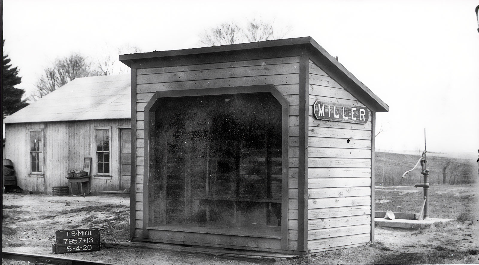 Waiting room at Miller Station, photographed 4 May 1920 by the Interstate Commerce Commission. Courtesy, Mark Worrall
The railroad company added a siding track at Miller Station, which allowed passenger trains to pass by while freight cars were being loaded and unloaded. This provided a convenient stopping place for vagrants who could “hop a freight” from Kalamazoo to Miller’s Station and then disappear into the countryside. For many years, “thieves,” “hoboes,” “tramps,” “crooks,” “foreigners,” and other such “suspicious characters” (Gazette) found refuge among the freight cars and in nearby barns and fields. Police vehicles at times raced from Kalamazoo to intercept the train at Miller’s Station where suspects could be apprehended.
“There was a chicken pie social at the Miller school house last Friday evening for the purpose of raising money for an organ.”
—Kalamazoo Gazette, 29 September 1905
For those who lived nearby, the Miller schoolhouse remained the centerpiece of the community. In addition to the many holiday, graduation, and other school programs put on by the teachers and their students, the school building continued to function as a wedding chapel, funeral home, meeting hall, concert venue, and general community gathering place.
Schoolhouse Fire
Life remained quiet at Miller’s Station until September 1916, when disaster struck the tiny community. During the early morning hours of Sunday, September 10, a fire of undetermined origin claimed the school building just days before the beginning of the new school year. The building had just been renovated over the summer with new wallpaper and a fresh coat of paint. Workmen had finished installing brand new seats and desks in the building just hours before the fire broke out. The beloved old schoolhouse was a complete loss.
Without a place to hold classes during the coming school year, property owner John Miller, Jr., offered to let the district use the parlor inside his home as a classroom. The old schoolhouse furniture that had recently been discarded was refurbished and installed inside the Miller home. Classes began in their temporary quarters on September 12.
The community rallied and by November 1916 plans had been made for a new school building at Miller Station. Well-known Kalamazoo architect C.A. Fairchild drew plans for a frame structure of mission styling with a concrete foundation to be built by local building contractor Jacob Van Dam. The project took just weeks to complete and classes began in the newly completed schoolhouse on January 29.
“Hard Times Parties”
During the Depression years the Miller schoolhouse continued to serve as the primary gathering place for the community. Social clubs and organizations like the Community Club of Miller School, the Happy Go Lucky Club, the Merry Go Round Club, and the Miller Parent-Teacher Association held meetings, music performances, and other forms of entertainment at the school. Pot luck suppers, “chili con carne suppers,” “wiener roasts,” and “hard times parties” saw area residents through the difficult times and often served up to 80 participants or more.
The Miller schoolhouse remained in use through the 1940s and 50s, closing only briefly during the Second World War. In March 1954 voters in the Oshtemo village school district elected to annex the Miller school district into the Oshtemo school district. The 28 students remained in the one-room Miller school building until the end of the school year, after which the building was closed. The old schoolhouse has since been used as a church and a private residence.
 Oshtemo Township, c.1969. Published by Directory Service Company, Farm and Home Publishers, 1969.
Today, there is little evidence of Miller’s Station. Passenger trains still pass the intersection of West ML Avenue and South 6th Street several times each day, but they no longer stop there. Tree-lined county roads and scattered residential buildings now mark the place where schoolchildren once played, workmen shoveled coal, and railroad workers tended their trains on the Michigan Central line.
Written by Keith Howard, Kalamazoo Public Library staff, May 2020
Sources
Books
History of Kalamazoo County, Michigan : with illustrations and biographical sketches of its prominent men and pioneers.
Samuel W. Durant, comp.
Philadelphia: Everts & Abbott, 1880.
R 977.417 H67W
Next Stop Kalamazoo! : A history of railroading in Kalamazoo County.
David C. Hager
Kalamazoo Public Museum, 1976
H 385 H144.
Articles
“Oshtemo Schools”
Kalamazoo Gazette, 17 July 1872, page 4
“Oshtemo”
Kalamazoo Gazette, 17 September 1879, page 1
“School Meeting At Oshtemo”
Kalamazoo Gazette, 23 July 1899, page 4
“To Reduce The Big Oshtemo Grade”
Kalamazoo Gazette-News, 14 June 1902, page 8
“Real Estate Transfers”
Kalamazoo Gazette, 30 April 1904, page 3
“Real Estate Transfers”
Kalamazoo Gazette, 21 August 1904, page 7
“Will Open New Line Sunday”
Kalamazoo Gazette, 10 August 1905, page 2
“Miller’s Station Schoolhouse Burns”
Kalamazoo Gazette, 11 September 1916, page 5
“School Burns; Hold Classes In Parlor”
Kalamazoo Gazette-Telegraph, 12 September 1916, page 5
“Fairchild Plans For Two Schools”
Kalamazoo Gazette-Telegraph, 15 November 1916, page 1
“Millers’ School Opens On Jan. 29”
Kalamazoo Gazette, 26 January 1917, page 6
“Miller School District Joins Oshtemo Unit”
Kalamazoo Gazette, 2 March 1954, page 18, column 7
Census Records
John Miller, 13 October 1876. Michigan Department of Community Health, Division for Vital Records and Health Statistics; Lansing, Michigan; Death Record
Online database, Ancestry Library (in library only)
John Miller household, 1860 United States Federal Census, Oshtemo Township, Kalamazoo County, Michigan
Michigan, Compiled Census and Census Substitutes Index, 1827-1870
Online database, Ancestry Library (in library only)
John Miller household, 1870 United States Federal Census, Oshtemo Township, Kalamazoo County, Michigan
Census Place: Oshtemo, Kalamazoo, Michigan; Roll: M593_680; Page: 272B; Family History Library Film: 552179
Online database, Ancestry Library (in library only)
Census Year: 1860; John Miller. Census Place: Oshtemo, Kalamazoo, Michigan;
Archive Collection Number: T1164; Roll: 9; Page: 43; Line: 10; Schedule Type: Agriculture
Online database, Ancestry Library (in library only)
Maps & Atlases
Map of Kalamazoo Co., Michigan.
Geil & Harley, Philadelphia. 1861.
Library of Congress
History Room atlas case, left shelf #2
Atlas of Kalamazoo County, Michigan from Recent and Actual Surveys and Records.
F. W. Beers & Co., New York. 1873
Library of Congress
Illustrated Atlas of Kalamazoo County [Michigan] with early and present history of Kalamazoo County
Sauer, William C.
Wm. C. Sauer, Detroit. 1890
History Room atlas case, left shelf #1
Railroad Map of Michigan, Southern Peninsula (Kalamazoo County).
Published by Rand McNally, Chicago, 1910.
Standard Atlas of Kalamazoo County, Michigan
Geo. A. Ogle & Co., 1910
History Room atlas case, left shelf #1
Atlas of Kalamazoo County, Michigan
Chicago: H.C. Maley, 1913
H 912.77417 K1410
History Room atlas case, left shelf #1
USGS topographic maps for Kalamazoo County, 1916, 1918 and 1922/1950
History Room map case, left drawer #1
Map. Plat book of Kalamazoo County, Michigan: compiled from surveys and the public records of Kalamazoo County, Michigan.
Rockford, Ill.: Thrift Press ; Kalamazoo, Mich.: Glen C. Wheaton, ?, 1928
Library of Congress
Map. Kalamazoo County 1969, Oshtemo T2S-R12W.
Published by Directory Service Company.
Farm and Home Publishers, 1969