Kalamazoo Street Names
Their Origins and History
A | B | C | D | E | F | G | H | I | J | K | L | M | N | O | P | R | S | T | V | W | Y
The following is a partial list of the origins behind the names of city streets, many of which were named after prominent members of business and politics. As with many aspects of history, the exact origins can often be a difficult matter to determine and verify as time passes, memories fade, and secondary sources fail to elicit certainty. We expect to add other origin stories as we find information about them, so check back later if you do not find what you are looking for.
 1844 Kalamazoo Plat Map
Miscellaneous Street Milestones
1881: First sanitary sewer laid
1884: Streets were paved with wood blocks
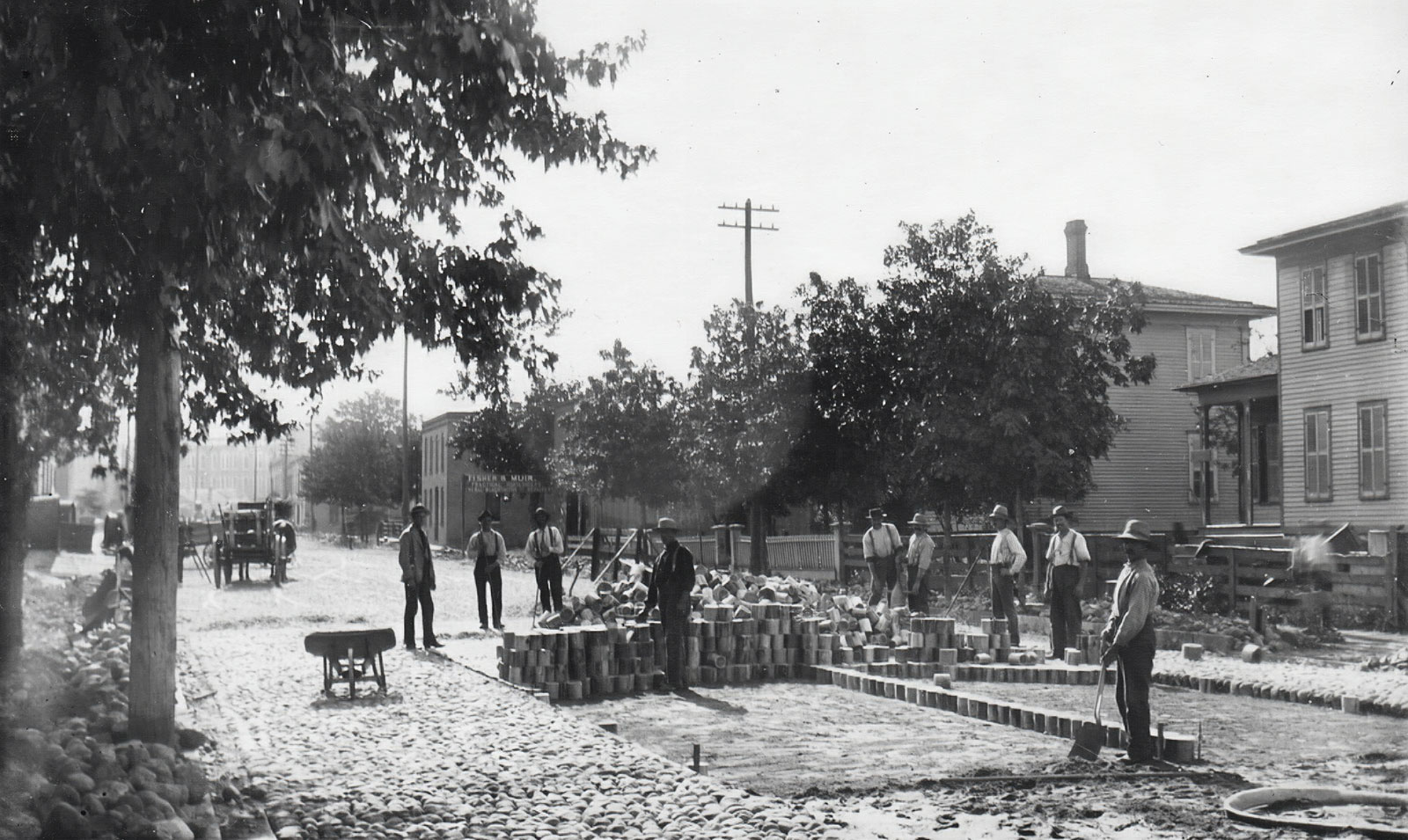 Paving North Edwards Street, 1884-88. KPL catalogue number P-208
1894: The introduction of brick streets
1903: The first asphalt was laid along W. South Street
1924: By this year, 52 miles of streets had been paved
1925: The effort to renumber homes and buildings completed
1925: On July 1st, Main Street was officially changed to Michigan Avenue
1932: Streetcar service is phased out
1949: The city’s parking meter ordinance went into effect. 531 meters were placed throughout the central business district.
1954-55: Kalamazoo’s street plan includes the increasing of one-way streets, including Westnedge, Park, South, and Lovell.
1965: On October 11th, Kalamazoo Avenue and Michigan Avenue become one-way streets.
1967: The Park Street extension project is completed. Park Street at Crosstown Parkway becomes connected southward to Westnedge Avenue near the top of Crane Park.
Academy Street
Once known as “Cow Alley”, Academy Street has long been associated with educational institutions. First, there was the University Michigan branch which was located along the eastern portion of Bronson Park, where Academy and Rose Street join. This area was later renamed Courthouse Square. But, as noted by the Kalamazoo Gazette, “In the early days the lots in Main Street and in South Street extended entirely through to Academy Street, and backed up on either side of the alley were barns, swine pens and shed of all descriptions. Everybody in those days owned a cow and in the early morning Academy Street resembled very much a dairy farm in full operation. It was, in fact, the dairy center of the village.” (KG, 2-8-1917)
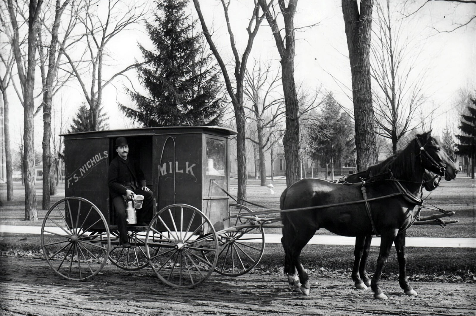 F. S. Nichols’ milk wagon on Academy Street side of Bronson Park, 1890-93. KPL catalogue number P-215
Acker Lane
Named for George Acker, who coached the Kalamazoo College men’s tennis team for 35 years. Prior to honoring Acker, the diminutive throughway located on Kalamazoo College’s campus, between Academy and West Main Street, was named Carmel.
Adams Street
This Oakwood street, like the nearby Madison and Hoover streets, were named for U.S. presidents.
Adelaide Street
More than likely named for the wife of Patrick H. Burke, an Irish developer and businessman behind Burke’s Addition, which includes the land where the Edison Neighborhood street is located. Located between Alcott and Luella Streets.
Alcott Street
Named after William Washington Alcott (Allcott) and his wife Deborah Bigelow Alcott. The Alcott home was situated on 12 acres of land near where S. Burdick Street meets Remine Street. The Alcott’s owned a flour mill off of Alcott Street, just east of the LS & MS railroad tracks, along the banks of the Portage Creek. William died in 1868, but his wife continued to live in the city until her death in 1900. Many years ago, the surrounding area was informally called Allcottville, although it was never incorporated.
Ampersee Avenue
Named for Marinus Amperse (aka Ampersee, Amberson), a Dutch grocer and land owner who platted the area east of the Kalamazoo River and parts of the Eastside Neighborhood. According to his obituary, he fathered 25 children. Runs north from Sherwood Avenue one block west of Riverview Drive.
Amsterdam Street
Another reference to the influence of Dutch immigrants, many of whom gravitated toward the wet, mucky land found on the northside so as to grow celery. Runs west from N. Westnedge Avenue to Woodward Avenue, just south of Business 131.
Ann Street
Runs from Stamford Avenue to Baker Drive one block north of East Main Street. Named for a daughter of John and Anna Balch denBleyker, who owned a large farm in the area.
Arcadia Street
see Burdick Street
Ashley Drive
This Eastwood Neighborhood street takes its name from early property owners Charles J. Ashley and his wife Elizabeth who established the Bishop Farm in the 1870’s.
Asylum Avenue
see Oakland Drive
Austin Street
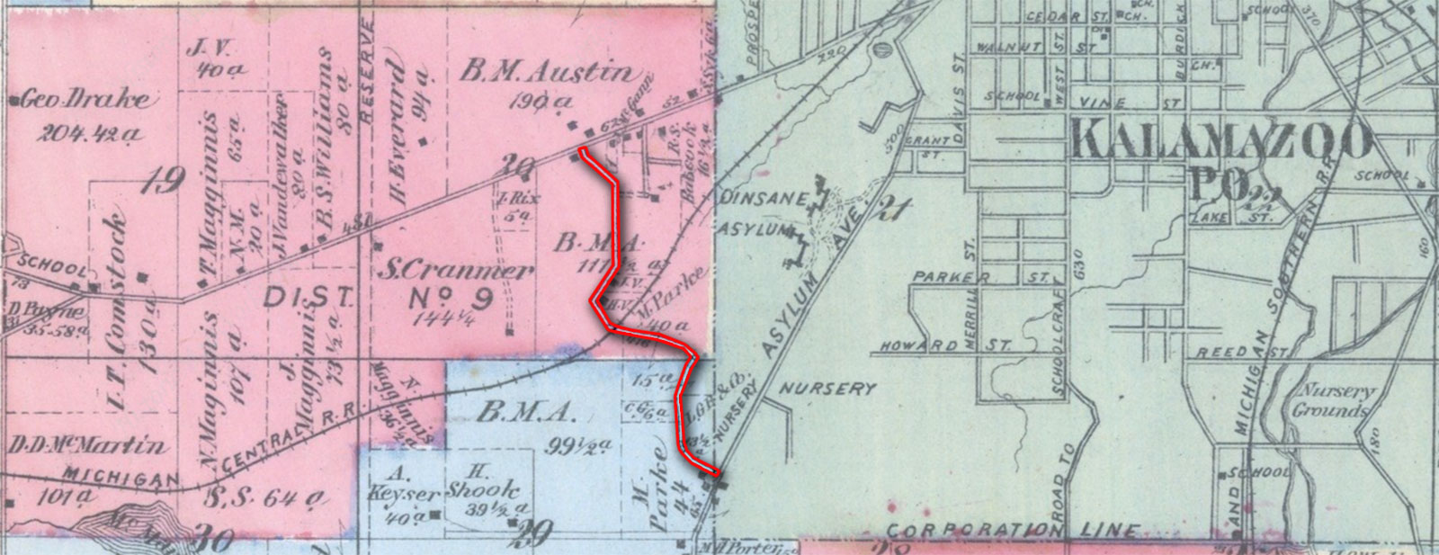
Named for Benjamin M. Austin, an early pioneer who came to Kalamazoo County with his parents in 1833. Austin’s father Moses was a farmer who operated the Austin House in Portage Township, near the lake that bares his name. Benjamin moved to Kalamazoo and went into the clock and watching making trade, before switching to dry goods. In the 1850s, Austin entered the wagon-manufacturing business, farmed and continued to be a prominent businessman until his death in 1896. His home was at the corner of Austin Street and Asylum Avenue (aka Oakland Drive).
Balch Street
Named for Nathaniel Balch, the first “manager” of the Michigan and Huron Institute.
Barnard Street
Named for pioneer Thomas W. Barnard, who owned property west of Woods Lake and south of Parkview Avenue, just west of the Stevens family farm. “Thomas Barnard arrived in time to help build the Kalamazoo House, the first hotel, and to assist in planning the layout of the streets.” (Henry, p.12)
Bates Alley
A narrow east-west street that runs between Portage and Edwards Streets, behind the businesses that open on the south side of East Michigan Avenue. Probably named for Charles R. Bates, a wholesale grocer on whose property the Humphrey Block/Peninsula Building was erected in 1855 on the southeast corner of the intersection of Portage Street and what is now East Michigan Avenue. In 2017 an effort was begun by Downtown Kalamazoo Inc. and others to upgrade the alley into “a vibrant, activated public space for outdoor dining, events and connecting with friends and neighbors.” (KG 10/6/2017) The alley links the main part of downtown with the entertainment district farther east.
Benjamin Avenue
Runs from Oakland Drive to Waite Avenue in the Winchell Neighborhood. Named after Benjamin A. Waite, son of pioneer Preserved S. Waite. The Waite farm was located north of Winchell Avenue and west of Oakland Drive.
Bessie Street
Possibly named for the daughter of John Dudgeon, an Irish immigrant who along with Thomas S. Cobb, developed the Dudgeon & Cobb Addition, a plat of 100 lots in the Northside Neighborhood, where the street runs.
Betsy Ann Place
From the May 6th, 1980 edition of the Kalamazoo Gazette, “It’ll probably cost me $200 or $300 before I’m done changing signs and stationary and everything,” laughed Kalamazoo businessman James Morren this morning, “but my wife hates the name of Dingley Road.” Morren’s wife’s name was Betsy Ann, and so the formerly named Dingley Road was changed to celebrate her 50th birthday. Morren owned seven acres of land that surrounded the tiny street that runs east off of Westnedge Avenue, bending toward Crane Avenue. At the time of the name change, Morren said that the Dingley Road street signs were stolen with great frequency. He had not found any source for the previous name, and so with the permission of the Kalamazoo City Commission, his wife’s name was written into the annals of Kalamazoo’s roadway history. Of course, there was indeed a source for the original street name. Edward Nelson Dingley was a former publisher of the Kalamazoo Telegraph and the Kalamazoo Press. He also served in the Michigan State Legislature during the late 1800s.
Blakeslee Street
According to the 1873 Kalamazoo Plat Map, a farmer named Lyman Blakeslee owned 7 acres of property just east of the intersection of Alamo Road and the Grand Rapids Road (aka Douglas Avenue). Blakeslee Street, just southwest of this area is likely connected to the 19th century farmer.
Blanche Street
Named for Blanche Hull
Boerman Avenue
This narrow street just south of Bronson Hospital was named after landowner Peter Boerman in 1901 after it was originally known as Kook’s Alley.
Bosker Avenue
Likely coined for Dutch immigrant, John Bosker, who owned property on where the short, northside street resides. Bosker was a woodworker, who in the early 1900s, was employed by the Globe Casket Company. By 1908, the name of the street shows up in the city directory. A Jacob and Peter Bosker also lived along the street.
Brentwood Avenue
Originally named Illinois Street, the Hillcrest Neighborhood street that runs north and south from Cherry to Howard, was changed to Brentwood in 1921. The reason: Illinois Street ran just west of Indiana Street, causing confusion for residents and visitors.
Burdick Street
Named for General Justus Burdick, early settler, leader and owner of the Kalamazoo House, one of the village’s first downtown hotels. Until 1844 it was known as Arcadia Street. (KG 10/19/1920) One of the main streets of Kalamazoo, it runs north from Kilgore Road almost to Allen Street, although a couple of blocks downtown are known as the Kalamazoo Mall.
 Facing south on Burdick Street, at the corner of South Street. Post Office is at right. KPL Photo P-1513
Burr Oak Street
“Burr Oak Street was given a name after the nick name given the village of Bronson. Owing to the fact that this city was located in burr oak woods the village was for many years called Burr Oak.” (KG 12-7-1902)
Bush Street

“The most prominent building contractors of the 19th century were Frederick Bush and Thomas Paterson. Their firm built many of downtown Kalamazoo’s most prominent public buildings, some of which, like the Ladies Library Association and the Intermodal Transportation Center (formerly the Michigan Central Railroad Depot) still stand.” (Museography, Winter 2011, p.17)
Bryant Street
Named for industrialist Noah Bryant, who was the president of the Bryant Paper Company.
Cameron Street
Named for Emma Cameron, daughter of politician and farmer Alexander Cameron.
Carmel Street
see Acker Lane
Cave Court
Named for James “Uncle Jim” Cave. Cave (1826-1900) was a British-born butcher who owned a business just west of the Kalamazoo River, near where Harrison Street and Gull Road meet in the late 19th century.
Cedar Street
“One of the prettiest drive ways in the state was the one leading to the doorway of Governor Ransom’s home. On both sides of the driveway was located lines of cedar trees. For a time it was called the Cedar driveway, but later the name was changed from Cedar driveway to Cedar street and it has remained such ever since.” (KG 12-7-1902)
Cellem Street
Named for Fred Cellem, for many years a prominent citizen. (KG 11-23-1919)
Charles Avenue
see Phelps Avenue
Charlotte Avenue
Anna Balch denBleyker stated that Charlotte Avenue was named for the wife of Judge Thomas Sherwood. Local records show that Sherwood’s wife was named Anna, so Mrs. denBleyker may have been mistaken, or Charlotte may have been an early deceased wife. It runs south from Gull Road to East Main Street and crosses Sherwood Avenue (KG 12-1-1929).
Clinton Street
Named after a 19th century citizen DeWitt Clinton Reed. Both Clinton and Reed Streets derive from the Edison Neighborhood landowner. Egleston Avenue was originally named DeWitt. “Reed’s son, Heber, married Emma Cameron, daughter of politician and farmer Alexander Cameron (Cameron Street).” (Museography, Winter 2010, p.18)
Cobb Street
Possibly named for Charles L. Cobb, a northside developer who platted between North, Burdick, Paterson, and Westnedge Avenue.
Conant Street
Conant derives from the maiden name of Caroline Hawley, wife of Emmor Hawley. The couple, originally from Vermont, owned a tract of property near the corner of Douglas Avenue and W. North Street.
Cooley Street
Named for Anthony Cooley, an early settler and artist who captured the first images of village life by painting a scene from the first court case in the county, as well as a rendering of Titus Bronson’s log cabin.

Cooper Avenue
see Dells (The)
Cork Street
Cork Street runs between Sprinkle Road on the east and South Westnedge on the west. West of Westnedge it becomes White’s Road, and past Oakland it shifts again and becomes Parkview. Cork was originally known as St. James, presumably after St. James Chapel, a mission of St. Augustine’s Catholic Church in Kalamazoo, which was established about 1890. Tradition has it that there were so many paper mill workers living in the area who immigrated from County Cork in Ireland that the street was also known as Cork Street. It was listed both ways in the city directories for many years. Because of the confusion, particularly affecting mail delivery, the Kalamazoo Township board officially named it Cork Street in 1930 (KG 12-28-30). According to a brief note in his granddaughter’s obituary, pioneer Cornelius Lacey provided this east/west road with its name (KG, 1-3-43), but we have been unable to confirm that statement.
Corporation Alley
Runs north from DeVisser Alley to Exchange Place between South Rose Street and the Kalamazoo Mall. It was named for Corporation Hall, Kalamazoo’s first city hall, which faced what was then South Burdick Street. (Sanborn map, 1908)
Cow Alley
see Academy Street
Dells (The)
One of the references to the novel Oak Openings by the 19th century writer James Fenimore Cooper, who was allegedly friendly with the denBleyker family, who owned land in the Eastwood Neighborhood. Nearby Oohna Place, Oak Openings, Cooper, and Fenimore streets are also nods to the writer.
Den Adel Court
This short court that runs east and west between S. Park and S. Westnedge is likely named for the den Adel family that owned the property in the early part of the 20th century. The den Adel’s were celery farmers who had immigrated to Kalamazoo from Holland. There was Cornelius den Adel and his brother Arie, both of whom lived near where the street is now located.
Denner Street
Likely named for George H. Denner, who was in the flour mill business in Kalamazoo in the late 19th century. Born in Ann Arbor in 1845, Denner was a veteran of the Civil War, and married to Eliza. He died in 1913 and is buried in Riverside Cemetery.
DeVisser Alley
A small alley running east/west that intersects the 200 block of S. Burdick St., approximately at the same location as the DeVisser & Co. hardware store (operated by John DeVisser) during the late 1880’s. DeVisser was an active member of civic and business affairs, including time spent as a longtime member of the Board of Education.
Dingley Road
see Betsy Ann Place
Douglas Avenue
Named by former U.S. Senator Charles E. Stuart for his friend and 1860 presidential nominee Stephen A. Douglas, whom Stuart invited to speak in Kalamazoo prior to his losing to the Republican candidate, Abraham Lincoln.
Drake Road
“Drake Road, the border of Kalamazoo and Oshtemo townships, is a reminder that Benjamin F. Drake’s 1830 homestead, located north of West Main Street, straddled that boundary.” (Museography, Fall 2009, p.18)
Dunkley Street
Joseph Dunkley immigrated from Somersetshire, England to Ontario, Canada when he was seventeen years old. In 1857, he arrived in Kalamazoo to work as a gardener and farmer of fruits. He purchased two lots along the 600 block of Pearl Street, where he lived and later built several green houses. In 1880 he entered the increasingly profitable celery industry, becoming the world’s largest seller by 1890. His celery fields were located near where the street that bears his name resides, just off of North Westnedge. Dunkley left the celery industry in the last years of his life, dedicating himself to the floral business. He died in 1898 at his home at 622 Pearl Street.
Dutton Street
Named in honor of a popular Professor William Dutton, who taught at the local branch of the University of Michigan. The portion of East Dutton Street from Portage Street to Portage Creek was originally known as Second Street. The name was changed by the city commission at the request of property owners in June 1939 (KG 6/27/1939).
Dwillard Drive
This Eastwood Neighborhood street is likely named for Henry Dwillard, a businessman who bought the nearby land in the late 1920s to plat Eastwood Heights.
Edwards Street
Named in honor of Major Abraham Edwards (only an honorary title), one of the early settlers of the city, and who headed up the the local land office where land holders could register their claims in 1834 (KG 12-1-1929).
Edwin Avenue
see Phelps Avenue
Elder Street
This small Eastside Neighborhood street was part of the Elder Addition. Likely named for Lucius M. Elder, a postal clerk who lived on nearby Trimble Avenue in the early 1900s, and who worked on trains from 1863 to his retirement in 1918. Lucius and his wife Eliza had a son named William D. and a daughter named Sarah. Sarah was a longtime English teacher for the Kalamazoo Public Schools.
Eldred Street
“Caleb Eldred was one of the two co-founders of the Michigan and Huron Institute, as Kalamazoo College was originally known. He chaired the school’s board of trustees for 25 years.” (Museography, Vol. 10, Issue 1, p.19). Eldred Street runs south from West Lovell Street to West Michigan Avenue.
Eleanor Street
“Eleanor Street is another of the early streets of Kalamazoo for which there is no authentic record as to the origin of its name. It was, however, one of the first streets mapped out in an addition opened by Anthony Cooley, for whom Cooley Street was named, and is believed to have been named in honor of some woman relative of Mr. Cooley.” (KG, 2-2-1917)
Wyllys C. Ransom, a pioneer from the city, told the Kalamazoo Gazette in 1902 that Eleanor Street was named for the wife of General Burdick. (KG, 12-21-1902)
Elizabeth Street
Possibly named after both the wife (Elizabeth R.) and the daughter (Elizabeth R. Parmelee) of William A. Tomlinson, who as part of Austin & Tomlinson platted the street in 1874. Tomlinson was from Connecticut. While in Kalamazoo, he was involved in the wagon manufacturing business. He died in 1900 and is buried in Mountain Home Cemetery.
Exchange Place
Runs from South Rose Street east past Farmers Alley. The origin of the name is unknown. (Sanborn map, 1908)
Factory Street
Located in a particularly industrial part of the Edison Neighborhood, the name derives from the many factories located nearby.
Farmers Alley
Originally named Farmers Avenue, this little street that runs north and south between Michigan Avenue and South Street, just east of the Kalamazoo Mall, took its name from the nearby site of an outdoor farmers market situated behind Gilmore’s Department Store. Today, this site is occupied by a parking ramp and retail space, but in the late 19th century, one would find a gathering of individuals that looked like the following photograph, taken by Schuyler C. Baldwin in 1884.
 Photograph by Schuyler C. Baldwin, 1884. KPL Photograph Number P-1443
Fenimore Avenue
see Dells (The)
Forbes Street
The addition was registered in 1887 by Calvin Forbes, which included lots along Hilbert Street, Forbes Street and Prospect Place. Forbes lived at the nearby residence of 425 Douglas in 1887, and was a harness maker by trade.
Gayle Avenue
Named for Gaylord ‘Gayle’ Vosler. The Vosler family owned farmland in the Eastwood Neighborhood, south of East Main Street, next to the Washburn farm.
Gertrude Street
Runs from Stamford Avenue to Baker Drive two blocks north of East Main Street. Named for a daughter of John and Anna Balch denBleyker, who owned a large farm in the area.
Gilbert Avenue
Named for the founder of the Kalamazoo Gazette, Henry Gilbert. (KG, 12-1-1929)
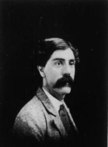
Gorham Lane
 William R. Gorham’s 1920 Western State Normal School Yearbook Photograph
Ruth Goodrich Nichols (daughter of Fred Sabin Nichols) married to William R. Gorham. It is possible the lane derives from William’s family.
Gourdneck Prairie Road
see Portage Street
Greenwood Alley
The origin of the name is unknown, although there have been Greenwood families in Kalamazoo throughout most of its history. It shows by name only on the 1873 Kalamazoo County Atlas, but is clearly visible on maps at least as early as 1853. It generally ran between Eleanor and Water Streets from Burdick to Park, and sometimes as far west as Cooley.
Harrison Street
Harrison Street was named for the son of Judge Bazel Harrison, considered the first white settler in the county (1828). Nat Harrison was the proprietor of the first hotel/tavern, situated along the banks of the river. He also owned and operated the well-used rope ferry, located nearby.
Hawley Street
Named for property owners Caroline Hawley and her husband Emmar (Emor), who had property both north and south of the intersection at North and Douglas Avenue in the early 1870s. Their son Edward owned much of this land upon his parents passing, living at 1009 W. North Street until his death in 1908. Edward, who was a veteran of the Civil War, owned the North Street Show Grounds, dabbled in real estate and sold furniture.
Hays Park Avenue
Running east from Portage Street to Fulford, Hays Park Avenue was named for Charles B. Hays, who developed much of Kalamazoo’s southeast side.
Hazel Street
Likely named for Hazel L. Stevens, a descendent of Oakwood Neighborhood pioneer Isaac Stevens, a settler in the 1830s.
Henderson Court and Drive
Named after Frank Henderson, who platted Henderson Park, built the Henderson Castle, and who operated the Henderson-Ames Company.
Holland Avenue
A short north/south street that connects W. Paterson Avenue with Harding Place. The name likely stems from the large Dutch population that settled on the northside of Kalamazoo during the late 1800s and early 1900s.
Horace Avenue
see Phelps Avenue
Hotop Avenue
Named after German immigrant Fred Hotop. Hotop bought and rebuilt the American Hotel after it was destroyed by fire. He platted the area on the street that bears his name.
Humphrey Street
Named for Elijah O. Humphrey, a prominent farmer who was active in civic affairs. (KG 12-1-1929; 1890 Kalamazoo Co. Atlas, p.97)
Inkster Avenue
Likely named after property owner Angus B. Inkster, whose nearby Inkster Park Addition was registered in 1912 with 74 lots.
Jail Street
see Park Street
Jasper Street
Named for Jasper S. Rice, the son of George W. Rice. George was probably the owner of Rice and VandeWalker’s Addition, recorded 1 May 1856, in which Jasper Street is located (KG 12/07/1902). It runs south from E. Lovell Street to Crosstown Parkway.
John Street
Named for the oldest son of Paulus den Bleyker. Originally it ran between East Vine Street and what is now Crosstown Parkway, east of Burdick Street, but it now extends north, somewhat lopsidedly around Bronson Hospital, to east South Street (KG 12-21-29).
Judge Avenue
Runs between West Frank and West North Streets, west of North Burdick. Named for George Judge, an early Kalamazoo brewer, who ran the Kalamazoo Malt House on that block in the mid- to late-1800s. (1873 Kalamazoo County atlas)
Kalamazoo Avenue
Named shortly after the Village of Bronson was renamed Kalamazoo in 1836. Kalamazoo Avenue at the time was the village’s longest roadway, extending from West (later Westnedge) to East Main Street, near where it coupled with Walbridge Street.
Kent Avenue
Originally named King Avenue for the King family who settled near Woods Lake and Parkview Avenue, it was later changed to Kent to avoid confusion with another street name.
Kilgore Road
John Kilgore moved to Michigan in 1835, and owned 400 acres at what is now Kilgore and Westnedge Avenue.
Krom Street
“Andrew Krom owned a farm near where Krom Street intersects Paterson Street. In 1871, he and Lucien Hascall laid out the small Krom and Hascall Addition.” (Museography, Winter 2011, p.17)
Lake Street
Eliza Warren had lived in her home at 839 Lake Street for 57 years when she explained the origins of the street name in a 1908 Kalamazoo Gazette article. “This house stands,” she recalled, “on what was then the corner of a farm of about 400 acres, owned by the late T.P. Sheldon, who bought the land of the government for $1.25 an acre. The marshy looking place on the north side of the house was at that time a pond and it was from this that the street got its name of Lake street. This pond was leased for 99 years to Mr. Walbridge for milling purposes, and it was not till 12 years ago that it was drained.” (Kalamazoo Gazette, 1 October 1908, page 5, column 3)
Lane Boulevard
Named for Moses Henry Lane, whose wife Ida was the sister of Lane’s business partner Frank B. Lay (of nearby Lay Boulevard). Lane was President of the Kalamazoo Wagon Company and the Michigan Buggy Company, the latter of which built a plant on the aptly named Factory Street. In an ironic twist, Lane died at the age of 80 from injuries sustained from an automobile accident in Los Angeles.
 Lane Boulevard looking East from Portage, Kalamazoo, c.1938, photographed by Slocum Bros. KPL catalog number P-1196
Lovell Street
“After three streets had taken on a sturdy growth and were spreading out to a considerable length, other streets began to branch out and it became necessary to give them names in order to distinguish them from the other streets. Lovell Street was given a name after one of the first settlers in the city, Cyrus Lovell. He owned property on this street and as he was considered one of the leading men in the village at the time and the town officials honored him by naming one of the new streets after him.” (KG, 12-7-1902) Lovell was also the first prosecuting attorney of Kalamazoo County.
Luella Street
see Phillips Street
Lulu Street
Possibly named after Lucy S. Cobb, the daughter of Northside Neighborhood developer Charles L. Cobb. An 1882 article published in the Kalamazoo Gazette referred to her as ‘Lulu’, a possible nickname. The street runs east/west off of Cobb Avenue on the city’s northside.
Main Street
see Michigan Avenue
Merrill Street
Named for prominent manufacturer David B. Merrill, who owned property in the Vine Neighborhood. He owned the Merrill Milling Company which operated several mills in the area.
Michigan Avenue
Prior to white settlers arriving, this section of Kalamazoo was an Indian trail that stretched from the Kalamazoo River toward Lake Michigan. “The street, the whole length, follows directly over this trail and the present Main Street bridge over the Kalamazoo River stands where the Indians used to ford the river. The trail from the east bank of the river extended east and East Main Street is now a part of the old trail.” (KG 7 December 1902)
In July of 1929, Main Street, the old territorial road, was renamed Michigan Avenue as part of a renaming effort focused on those cities along the path of U.S. 12 highway between Detroit and Chicago. Each city’s primary, downtown artery was to be named Michigan Avenue.
“The commission authorized the change in name of U.S. 12 through Kalamazoo after several petitions favoring the renaming had been received. The commission also had received protests against the change, some of which came from old established firms whose officials did not desire to have addresses familiar to patrons in many parts of the United States, changed.” (KG 6-16-29)
Milham Avenue
John Milham owned property near what is now Lovers Lane and Milham Road. One of the founders of the Kalamazoo Paper Company, he also donated the property that became Milham Park.
Mills Street
A large number of grain mills were located nearby.
Millview Street
Not unsurprisingly, this street got its name from its view of several paper mills.
Molhoek Court
Named for Peter Molhoek, who had property at the corner of Forest Street and S. Westnedge Avenue in the early 1900s. Molhoek was a city alderman and street commissioner. He was also involved in the gravel and sand business.
Myrtle Street
see Richardson Street
Nassau Street
Runs between East Main Street and Gertrude Street. Named for the royal family of the Netherlands, the homeland of the denBleyker family, who owned a large farm in the area.
Nellbert Street
Named after the developer Harry Hurni’s wife Nell Hurni. Hurni developed the Kennelworth Park addition in the 1940s.
Newell Place
Named for John A. Newell, who platted the area east and south of South Westnedge Park (aka Pioneer Cemetery) in 1866. Newell was part owner of the Kalamazoo Tubular Well Company, a business that manufactured equipment for well digging.
Nichols Road
Runs north from West Main Street and becomes 14th Street north of G Avenue. it is named for the family of Sabin and Sarah Nichols, who came here from Vermont in 1843, purchased 160 acres northwest of Nichols and Main and established a dairy farm.
Normal Court
More than likely, this Vine Neighborhood court was named for the nearby Western State Normal School (later Western Michigan University) that stood atop Prospect Hill.
Oak Openings Street
This small Eastside Neighborhood street sits next to Sherwood Park. The name derives from the James Fenimore Cooper novel The Oak Openings (1848). It has been suggested that the author was friendly with the denBleyker family, who had a farm and properties nearby. Fenimore and Cooper Avenues take their name from the famous American writer.
Oak Openings
see Dells (The)
Oakland Drive
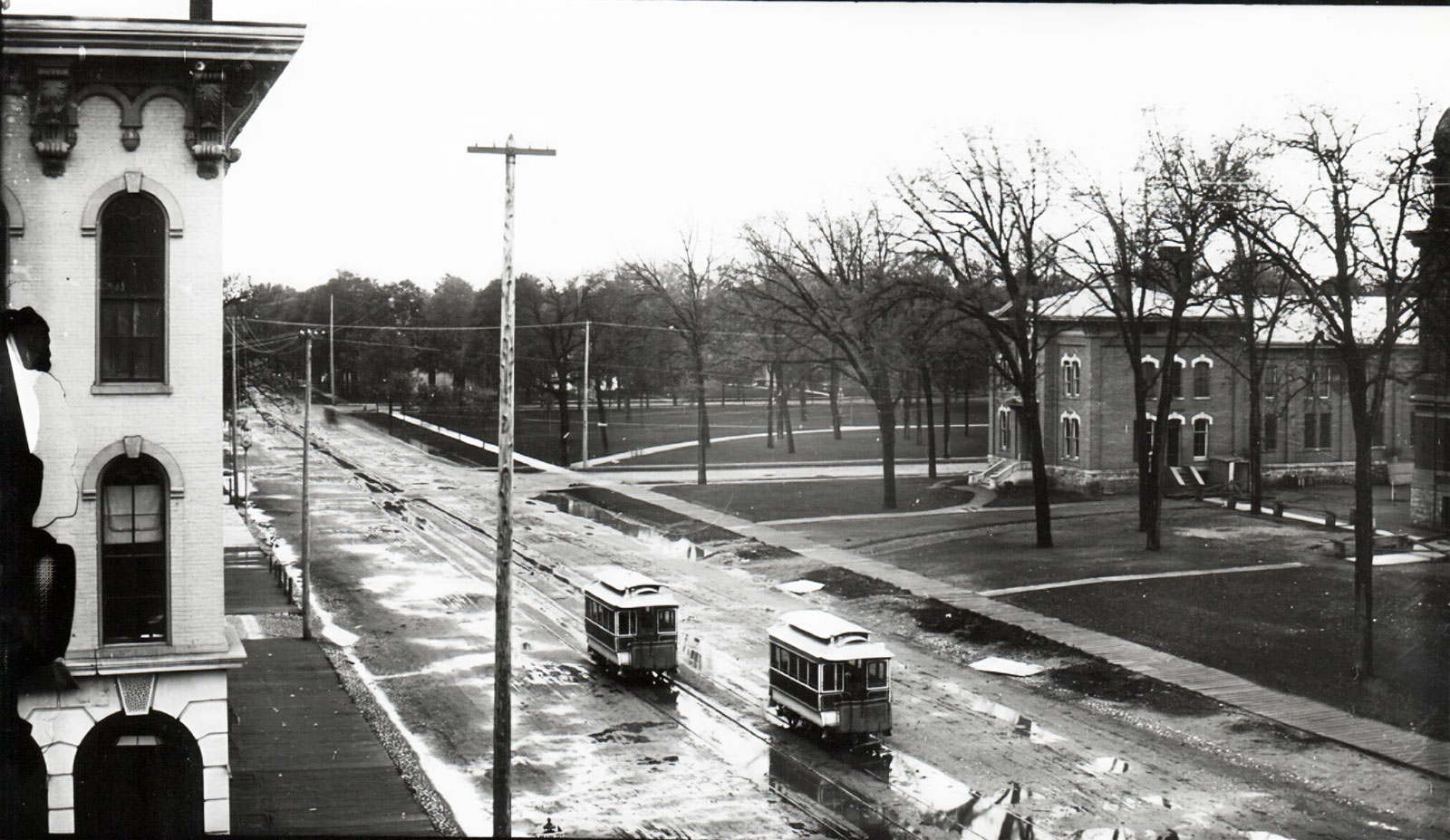
Originally established as the Genesee Prairie Road by the Township Highway Commission on 2 February 1833, the name came to be known as Asylum Avenue–named for one of the north/south thoroughfare’s most prominent institutions, the Kalamazoo State Hospital. Oakland Drive became the name on 4 March 1912. (Encore, June 2020)
Oliver Street
Likely named for Andrew Oliver, a 19th century property owner whose land sat west of Oakland Drive and north of the Michigan Asylum for the Insane. Oliver was the proprietor of the City Vegetable Gardens, a “dealer in all kinds of vegetables in season” according to the 1878 Village Directory.
Olmstead Road
Named for farmer Luke Olmstead, who owned 80 acres of property at the intersection of Olmstead Road and Lake Street by 1873. He died in 1875 and is buried in Riverside Cemetery.
Oonah Place
see Dells (The)
Palmer Avenue
Likely named after high-ranking official of the Michigan Buggy Company, Victor L. Palmer.
Park Street
“Park Street was known before 1845 as Jail Street. The old village bastille constructed of logs and poles was located on the street where the present Congregational church stands but later it was moved from this place over in the same block where the court house is now located. Shortly after the jail had been moved, Titus Bronson, for whom the village of Bronson was named, gave to the city the land where Bronson Park is located and as considerable objection was made by the people who lived on Jail Street to its name the town council changed the name to Park Street.” (KG 12-7-1902)
Parsons Street
Jonathan Parsons, a hardware merchant, owned a large lot near where the Lincoln International School now stands. He platted the area around that lot as the Parsons Addition in 1867. Guitar lovers will recognize Parsons Street as the location of the old factory that once housed the Gibson and Heritage Guitar Companies. (Museography, Winter 2011, p.17)
Paterson Street
see Bush Street
Peeler Street
Named for former City Assessor George C. Winslow’s pet dog (KG, 11-23-1919)
Phelps Avenue
Located on the city’s east side, Phelps Avenue is likely connected to Horace Phelps, part owner of the Bigelow and Phelps Windmill Company. “Phelps had two sons, Edwin and Charles. Perhaps it’s not surprising that there are streets named Phelps Avenue, Horace Avenue, Edwin Avenue, and Charles Avenue in the addition.” (Museography, Summer 2010, p.18)
Phillips Street
Phillips Street runs west from Portage Street a few blocks north of Cork Street. Named for Delos Phillips, an organ manufacturer who platted a small addition in the Edison Neighborhood in 1884. Luella Street, which runs north from Phillips, is named for Phillips’ oldest daughter. In 1889 she married Charles B. Hays, who developed much of Kalamazoo’s southeast side. (Museography, Winter 2010, p.18)
Pomeroy Street
Runs west of Lovers Lane, north of E. Cork Street. Named for the family of pioneer Norton Pomeroy.
Portage Street
Established as the Kalamazoo and Three Rivers Plank Road, it was also called Gourdneck Prairie Road. When the Plank Road Company vacated the right of way on 9 May 1833, the present street was established by the Township Highway Commission.
Porter Street
It is possible that Porter Street was named in honor of George F. Porter, one of the early settlers of the village, or a Deacon Porter, who “had a restaurant at the corner of Main and Porter streets in 1835.” (Museography, Fall 2009, p.18)
Prouty Street
“Amariah T. Prouty platted several additions, including one as early as 1847 in the Stuart Neighborhood where his house still stands on Elm Street. He also owned a farm on the northern edge of the community where Prouty Street is located.” (Museography, Winter 2011, p.17)
Race Street
Named for its close proximity to the National Driving Park, a popular 19th century horse-racing complex situated in what became the Edison Neighborhood.
Ransom Street
Named in honor of Epaphroditus Ransom, the only Michigan governor to have hailed from Kalamazoo.
Reed Street
Named for DeWitt C. Reed, a farmer and manufacturer of spring-tooth harrows. Reed’s home was located at the corner of Reed and Portage streets in the late 1800s.
Remine Street
In 1873, Dutch immigrant Gerard (aka Garrett) Remin (aka Remyn, Remine) resided in his home on S. Burdick, just southwest of Alcott Street. Remin had been born around 1825 in Holland. Census data suggests he was a “laborer” and a “gardener.” He was married to Janey and had a son named Richardson (aka Richard). Gerard died in 1910 and is buried in Riverside Cemetery. Richard was a longtime clerk for the George T. Bruen Dry Goods Company. Richard died in 1939 and is buried in Riverside Cemetery. Given the street’s proximity to Garrett’s home, the land likely stayed in the family until it was sold and platted upon Gerard’s death.
Reverend Wright Court
Named after the former pastor of the nearby Second Baptist Missionary Church, who led the congregation from 1970 to 2009. The name of the court had previously been Butler Court before the city changed it to honor Rev. Matthew W. Wright in 2012.
Richardson Street
“Thomas Richardson and Myrtle Wattles, who ran a butcher shop, platted two additions in 1868 north of North Street between Pitcher and Walbridge streets. Residents of that area today are familiar with three short streets, Richardson Street, Myrtle Street, and Wattles Place.” (Museography, Winter 2011, p.17)
Rose Street
Likely named for the daughter of city pioneer Thomas C. Sheldon. Rose was characterized as the “belle” of Kalamazoo. The street was originally three feet lower than it is now (KG 12-1-1929). When the road is excavated during some construction projects, the older version can still be seen.
 South Rose Street, south from Main Street, 1885-1893. Jail visible at right center. Second county courthouse partially visible at extreme right. Street cars in center of photo. A portion of a building on the east side of Rose Street can be seen on the left. Bronson Park appears in the background on the right. KPL catalogue number P-310
Sabin Street
Likely named after Sabin Nichols, a 19th century property owner who had a farm on Grand Prairie, Kalamazoo Township.
St. James Street
see Cork Street
Saxonia Lane
This small street that runs parallel with Oakland Drive and butts up against the Kleinstuck Preserve owes its name to the state of Germany (Saxony) from which Carl G. Kleinstuck emigrated from.
Schipper’s Lane
An Eastside Neighborhood roadway off of E. Michigan Avenue, near the Kalamazoo Paper Company mills. One of the first uses of the name appears in a newspaper article from 1911. Likely named after the property owner Hendrik L. Schippers who had a nearby celery farm.
Scudder Court
William S. Scudder was a pioneer farmer who lived in Portage Township until his death in 1883. It’s possible the northside court that runs from E. Frank Street north to E. Parsons Street, could have been named after him. William’s daughter Emma B. Scudder married William Milham, son of the Honorable John Milham. The court was platted prior to 1904 as part of the J.B. Trowbridge Addition, and originally named Pitcher, but it was in this year, the name change occurred.
Sheldon Street
Situated in an industrial section of the Edison Neighborhood, Sheldon Street is named for Theodore P. Sheldon, a Kalamazoo pioneer associated with the Federal Land Office and Kalamazoo’s first bank.
Sherwood Avenue
“It’s named for Thomas R. Sherwood, a prominent attorney and an associate justice of the Michigan Supreme Court. He owned three acres of land on the west side of East Main a bit north of Michigan Avenue in the Sherwood Addition. The East Avenue School later was located on this property.” (Museography, Summer 2010, p.18)
Solon Street
Solon J. Nichols came to Kalamazoo in 1873, settling in the Grand Prairie portion of the township. He owned property near where the street is today.
Sprague Street
 Arthur P. Sprague. Western Michigan University Photograph
Likely named for Arthur Plummer Sprague, a successful businessman from Maine who opened a downtown shoe and boot store in the 1870s. He moved into a stately home at the nearby 1022 Academy Street in 1881.
Spring Street
Originally ran from 351 Portage (between South and Lovell) northeast to Pitcher Street, but has been replaced by Pfizer buildings in recent years. It was named for an especially clear, cold nearby spring. (KG 9/10/1922)
Stanwood Street
“Probably named for the Rev. Henry C. Stanwood who was on the [Kalamazoo] college’s governing board from 1857 to 1884.” (Museography, Vol. 10, Issue 1, p.19)
Stearns Avenue
The 1910 Kalamazoo Plat Atlas lists an Emma Stern as the property owner along what was also the street (which shows up without the ‘a’ on some maps as Stern Avenue). Henry and Emma Stern were part of the German-Jewish community who were very active in the social and commercial affairs of the city. Henry and his brother Leopold operated the H. Stern & Co., a clothing and furnishing goods store at 125 E. Main for many years in the late 19th century. They owned property in the Hillcrest Neighborhood despite residing in the Vine Neighborhood.
Stevens Avenue
Named for pioneer Isaac T. Stevens and his family, who had established a farm just south of Woods Lake and Parkview Avenue. “In 1834, Isaac and his wife, Elizabeth Pelton Stevens, and their 6-year-old son Andrew Jackson, named after President Andrew Jackson, (1829-1837) joined a large group of pioneers anxious to settle in the west. Traveling by water and then by oxcart, they followed the only road west and arrived at White Pigeon. Many of the party were sick and returned home. The Stevens family , however continued on and settled in Lake View (pre-Oakwood) in 1834, purchasing 80 acres. They cleared, cultivated and lived on their land. Stevens was the first blacksmith in the area and worked at his trade for 30 years. Isaac and Elizabeth raised a family of three sons (Andrew, Isaac, Lafayette) and four daughters. In 1852 Isaac and his son, Andrew Jackson, purchased more land. Elizabeth died in 1877 and Isaac remarried Caroline shortly after his first wife’s death. After Isaac’s death (1879), and the reading of the will, the sisters were dismayed to find they were not included in the land estate. They unsuccessfully contested the will in court. Isaac P. and Lafayette inherited the land and Lafayette stayed in the farm house and took care of his step-mother.” (Henry, p.16)
Stockbridge Avenue
“Stockbridge Avenue takes its name from Francis B. Stockbridge. A lumber baron, manufacturer, and real estate investor, Stockbridge was later a U.S. senator from Michigan. Stockbridge and his business partner, Lorenzo Egleston (Egleston Avenue), bought the National Driving Park, a former race track located east of Portage between Stockbridge and Reed streets. Together with prominent real estate developer, Charles B. Hays (Hays Park Avenue), they developed the Hays Park Addition in 1900.” (Museography, Winter 2010, p.18)
Stone Street
Named in honor James A.B. Stone, the first president of Kalamazoo College, and his wife Lucinda Hinsdale Stone, a noted suffragist. (Museography, Volume 10, Issue 1, page19)
Streeter Lane
see Van de Giessen Road
Stuart Avenue
Named for Charles E. Stuart, an attorney and later U.S. Senator who arrived in Kalamazoo in 1835.
 Northwest corner of Stuart Avenue and West Main Street, Kalamazoo, c. 1894. KPL catalog number P-981
Sunnyside Drive
Named by John denBleyker, a farmer and businessman from the Eastwood neighborhood. The sun hit their home on that particular side, and thus a street name was born. Runs between East Main Street and Gull Road.
Taliesin Drive
Located in the Parkwyn Village subdivision of the Winchell Neighborhood, the street’s name derives from the famous architect Frank Lloyd Wright, who designed several nearby homes. Wright’s Wisconsin home, work studio and garden sanctuary was called Taliesin, a word used to embody Wright’s ideas about organic architecture.
Texel Drive
 John denBleyker, c.1910
Named by family members of the denBleyker family, who had emigrated from Texel, an island of the coast of the Netherlands. The streets Ann, John, Gertrude, and Walter are also associated with the denBleyker’s, who immigrated to the Kalamazoo area around 1850. John denBleyker and his wife Anna platted the streets north of East Main Street, east of Stamford Avenue.
Van de Giessen Road
A curvy farm lane that wandered between the Territorial Road (Michigan Avenue) and the Grand Prairie Road (Oakland Drive). Appears first on the 1873 map of Kalamazoo County (F. W. Beers & Co.). Named for John and Henry Vande Giessen who owned adjoining farms just north of the Michigan Central tracks. Also called Streeter Lane (c.1890s) as it crossed the property of D.D. Streeter, who operated a large horse breeding farm. The portion south of U.S. 12 (Stadium Drive) was renamed Waite Avenue in 1957. A portion was replaced in 1964 by the westward extension of Howard Street. Most has since been eliminated by WMU campus expansion, save for a small curve between Howard Street and Ring Road.
 Atlas of Kalamazoo County, Michigan. Published by F. W. Beers & Co., 1873. Local History Room.
Vanzee Street
The 1878 Village Directory lists a Frederick Vanzee as living on nearby Alcott Street. Vanzee was involved in the real estate business, and is likely the inspiration for the street, which was platted in 1884 under the Vanzee Addition.
Waite Avenue
Named for William T. Waite. The son of an early Kalamazoo pioneer (Preserved S. Waite…son of George and Betsey). Waite was a successful farmer who had properties along Cork Street, Oakland Drive and W. Main Street. Waite died in 1943.
Walbridge Street
Named for David S. Walbridge, a “grain dealer who operated a small fleet of flat boats carrying grain down the Kalamazoo River to Lake Michigan. He was also a founder of the Republican Party.” (Museography, Fall 2009, p.18)
Wallace Avenue
Runs north from East Michigan Avenue, past East Main Street to Center Street. It probably was named for Annie Wallace, the wife of Thomas Sherwood, who owned land in the Eastside Neighborhood, including Sherwood Park, which is immediately east of Wallace Avenue.
Washburn Street
Named after the Washburn family, who owned farmland south of East Main Street.
Water Street
“How Water Street came by its name is not definitely known but the general supposition is that the race way that was built near the present line of the street suggested to the town council a name for the street. A race was built by early settlers along its course and the saw-mills and old grist mill received their power from it. The race was later filled up and the street constructed over it. It is thought that the name was given to it on this account. For three or four years after it had been filled with dirt and logs it was almost impossible to use it owing to the springs and water soaking through the soil, making it almost impassable.” (KG 12-7-1902)
Wattles Place
See: Richardson Street
Westnedge Avenue
Formerly West Street, originally the western boundary of the village. In 1920 it was renamed for war hero Col. Joseph Westnedge and his brother Dr. Richard Westnedge, both of whom gave their lives in service of our country, Richard in the Philippines during the Spanish-American War, and “Col. Joe” in France near the end of World War I. (Encore, June 2020)
Wheaton Street
Named for early resident William G. Wheaton. The New York state born Wheaton was a civil engineer and his wife Laura was a physician. The portion of the street west of Davis Street, that slopes sharply toward Oakland Drive was once a “vine yard.” The portion of the street east of Davis toward Westnedge Avenue was platted sometime by 1873, and was the southern border of the Agricultural Fairgrounds that once brought hundreds of spectators together to watch horse racing. Wheaton died in San Francisco in 1875, and is buried in Rockford, IL. According to Laura’s obituary, she was the first woman to practice medicine in Michigan, Minnesota and Vermont.
White’s Road
Named for James M. White, a farmer who owned 135 acres of property east of Oakland Drive (aka Asylum Drive) along the road that would bear their name. Albert R. White was James’ son, and he eventually sold the land to the Kalamazoo Country Club in the early 1900s after his father passed away in 1893.
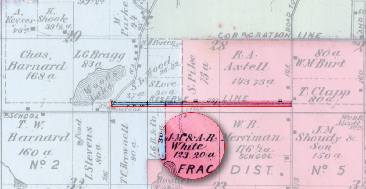 White’s Road. Kalamazoo County map published by F.W. Beers & Co., 1873. Local History Room
Willard Street
Named for pioneer merchant and former postmaster Isaac W. Willard.
Woodward Avenue
Named for Frederick E. Woodward, who owned property north of Kalamazoo Avenue and south of W. North Street, between Elm Street and Stuart Avenue.
Written by Ryan Gage, Kalamazoo Public Library staff, July 2022. Last updated 18 February 2026.