Westnedge Hill
A 20th Century Neighborhood
 “Westnedge Avenue”, painting by George Wilke Reed, c.1870. Kalamazoo Valley Museum Collection, 50.53.A
Today’s fashionable Westnedge Hill Neighborhood is uniquely split into three parts by S. Westnedge Avenue and Bronson Boulevard. It’s contemporary boundaries stretch northward toward Howard Street, southward to Whites Road/Cork Street, eastward to Burdick Street, and westward to Bronson Boulevard. It also lays claim to slivers of the Hillcrest Neighborhood. The area is almost entirely residential (over 1100 homes) with almost no past traces of 19th century industrial business. According to a profile piece in the Kalamazoo Gazette in 1990, the Westnedge Hill possessed the nickname of the “sidewalk neighborhood” for its wide, attractive, tree-lined streets.
The neighborhood’s prominent landmarks include Crane Park, Parkwood-Upjohn Elementary School, Kleinstuck Land Preserve, the Everyman’s House, Inkster Avenue bridge, Edgemoor water tower, the original setting of the Pine Crest Sanitarium, the Westnedge Hill Apartments (built in 1957), and Zion Lutheran Church. When first developed, Westnedge Avenue was still called West Street, as Col. Joseph B. Westnedge had not died until 1918 (official name change came in 1920). The neighborhood features an ecclectic mix of architectural revivalist styles popular in the early 20th century (Tudor, Colonial, Bungalow, Four Square, Modernist, e.g.). The west side of the neighborhood exhibits a far less gridded layout, as it was molded to compliment the hilly terrain and Bronson Boulevard’s curvy ascent. The neighborhood came of age in the early decades of the 20th century, becoming home to the city’s growing middle and upper classes, many of whom saw in the pastoral beauty of the area and large lot sizes, a pleasant respite from the overcrowded neighborhoods of downtown. Several large additions (parts of a neighborhood) make up the neighborhood, starting around 1910, when the Sunset Heights Addition was registered. Before its 20th century transformation, much of the wooded area was comprised of apple orchards, sometimes dubbed “Winslow Woods.”
Martin Heydenburk
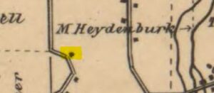 The 1861 Kalamazoo County Plat Map shows Heydenburk’s home along the then curved portion of road that would later become S. Westnedge Ave.
In 1860, three decades after settlers descended upon the Village of Bronson to cast their financial fates and fortunes to the winds of a rough and tumble pioneer life, there existed just a few traces of settlement around what became one of the city’s second wave neighborhoods, mostly platted in the early part of the 20th century. Deacon Martin Heydenburk, a religious missionary, carpenter was an early pioneer who purchased a sizable swath of land on the hilly topography. Around 1840, he built a large farmhouse for his family, which included his daughter Mary, the first white child born in the township in 1834. The Heydenburk home remained on the side of the hill until the early 1990s, when it was torn down. Before being known by its current moniker, the hilly area was known as Heydenburk Hill or Deacon Hill. Heydenburk farmed the open land around his home, producing milk for local customers like the Kalamazoo House. After a couple of decades of farming, Heydenburk sold his farmhouse property and moved to 515 S. Rose Street. He died in 1880 and was buried in Mountain Home Cemetery.
 The Heydenburk farmhouse along Betsy Ann Place, c.1983. History Room Photograph File P-1363
Another property owner who purchased nearby land during the first few years of Township settlement was Orrin N. Giddings, a native New Yorker who worked in real estate as well as state politics; representing Kalamazoo County in the 1840s. J.M. Edwards and Frederick Booher also show up on the 1861 plat map as property owners on land now part of the neighborhood. Booher was at one time before his death in 1861, the second owner of Kalamazoo’s first hotel, the Kalamazoo House. By 1873, the farmer Riley Ambrose Axtell and the iron manfuacturer William M. Burt owned properties on either side of West Street, south of Inkster Avenue. Burt sold 40 acres of land to local attorney Edgar A. Crane, who built his stately Queen Anne in 1895 at the corner of Grandview and Crane Avenues. Crane’s will included a provision that deeded a portion of his farm to the City of Kalamazoo, who then developed Crane Park on the land.
 The 1873 Kalamazoo County Plat Map still shows the neighborhood as undeveloped. The Corporation Line is roughly Inkster Avenue today. The bend in Westnedge Ave. may have been due to the steepness of the road.
Parkwood Addition
 Kalamazoo Gazette, 25 September 1916
Led by real estate developer Harry denBleyker, a local businessman whose grandfather led the first wave of Dutch immigration to the Kalamazoo area, his Kalamazoo Improvement Company registered the Sunset Heights Addition in 1910 and Parkwood in 1912. DenBleyker and his associates wanted to create a thruway that would connect the brand new Kalamazoo Country Club on White’s Road to the nascent neighborhood thru to downtown. The two most significant reasons why developers like denBleyker were able to act upon their vision was the addition of the South Westnedge streetcar line and the development of automobiles that were powerful enough to ascend Westnedge Avenue and Bronson Boulevard. Also, beginning in the later part of the 19th century, West Street had been regraded and straightened, shaving off around 30 feet from the top, making it far more accessible to travelers. And like those involved with developing the suburban Henderson Park Neighborhood, denBleyker marketed his new lots (131 in total) as a ‘back to nature’ escape from the polluted and congested confines of downtown. The Kalamazoo Land Company and the Crane Heights Realty Company were the two other developers during this time period which divided old farmland into desirable lots. The other additions that filled out the neighborhood boundaries were Shakespeare Park (1910), Sunset Park (1912), Crane Park Heights (1913), Crane Park Heights (1926), and Belmont (1920). By 1920, the building boom was on which meant the coming of enhancements like street lights, sewers, gutters, utilities, curbs and sidewalks.
“The man who loves to live close to nature will find the hills and dales of Parkwood particularly attractive. This beautiful sub-division formed out of the Winslow woods on the rolling ground to the west of South West street now contains many of Kalamazoo’s most pleasing homes.
Kalamazoo Gazette, 25 Septemember 1916
One of the more notable landmarks of the past that vanished from the neighborhood in 1939 was the imposing brick, steel and concrete standpipe located on the northwest corner of Inkster and Westnedge Avenues. Built in 1913, it cost $55,000 and held 500,000 gallons of water. The lot was later filled in with homes.
 Standpipe, c.1935. Kalamazoo Gazette Photograph Archive
Architectural Eclecticism
For an in-depth analysis of the various architectural styles one can observe in the Westnedge Hill Neighborhood, watch this entertaining and informative video presentation by local historian and neighborhood resident Lynn S. Houghton.
 Edgar A. Crane House, 2025. Ryan Gage
The neighborhood association was formed in the mid-1980s, and continues to provide new and old residents alike with information about current issues facing the neighborhood.
Written by Ryan Gage, Kalamazoo Public Library staff, September 2025
Sources
Books
Kalamazoo lost & found
Lynn Smith Houghton and Pamela Hall O’Connor
Kalamazoo Historic Preservation Commission, 2001
H 720.9774 H838
Articles
“Parkwood is fast growing in popularity”
Kalamazoo Gazette, 25 September 1916
“Westnedge Hill – Parkwood”
Kalamazoo Gazette, 4 February 1990, page C1, column 1
“The hill takes shape”
Encore Magazine, October 2007, page 44
Local History Room Files
Subject File: Westnedge Hill Neighborhood
Online
Westnedge Hill Neighborhood Association
Everyman’s House Presentation
History of Crane Park Presentation